Bantry Bay Blueway is an inviting water-based trail that will tempt you out onto the waters of Bantry’s spectacular bay which flanks the Sheep’s Head peninsula on its northern side
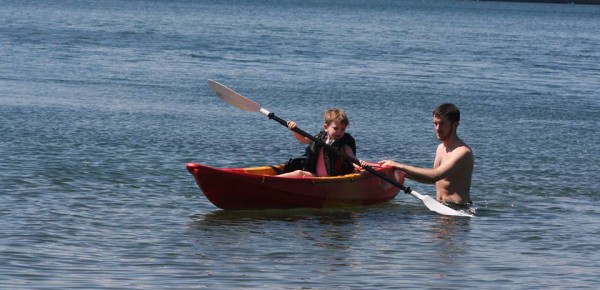
The trail offers a host of activities like kayaking, paddleboarding and sailing, suitable for everyone from beginners to more experienced sailors. Around Bantry’s shoreline, out on Whiddy Island, and around the bay, you’ll find information boards with trail maps, safety details, and tips on equipment hire and tuition.
The three trails available on the Bantry Bay Blueway are graded for beginners, intermediate, and advanced kayakers, so people of all ages and abilities can get out onto the water.
The famous bay runs approximately 35 km (22 mi) from northeast to southwest into the Atlantic Ocean. It is approximately 3-to-4 km (1.8-to-2.5 miles) wide at the head, and 10 km (6.2 mi) wide at the entrance. Two of West Cork’s inhabited islands – Bere and Whiddy – are located within Bantry Bay.
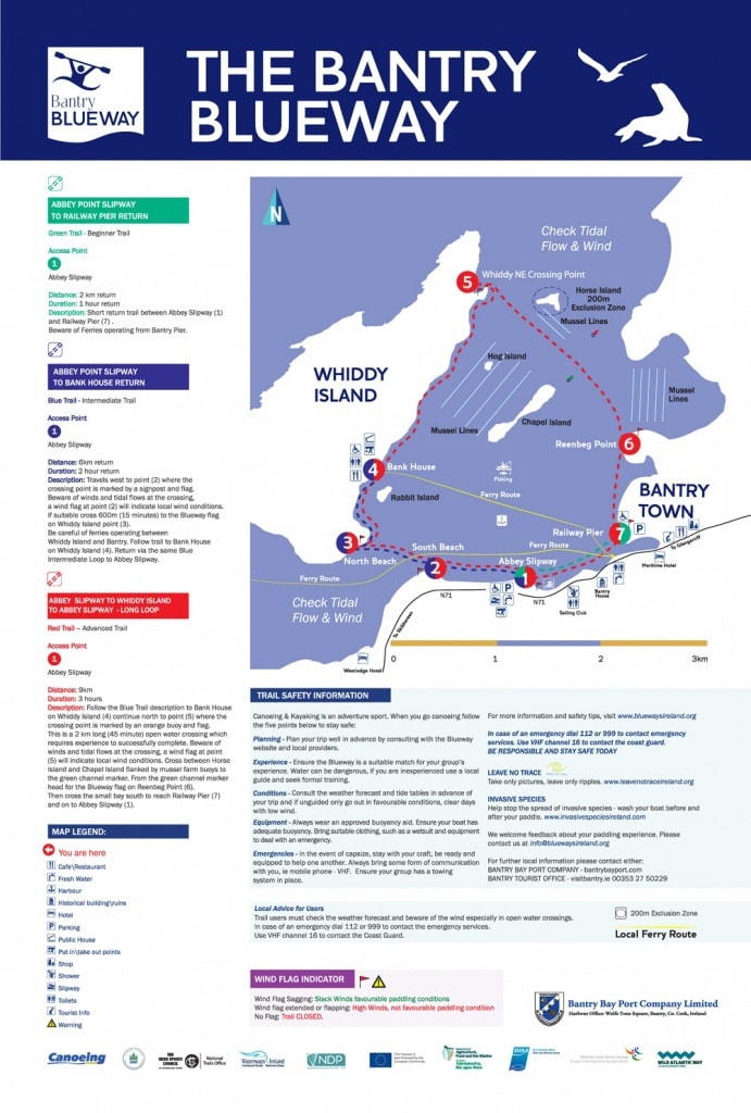
ABBEY POINT SLIPWAY TO RAILWAY PIER RETURN
Green Trail: Beginner Trail
Access Point: Abbey Slipway
Distance: 2 km return Duration: 1 hour return
Description: Short return trail between Abbey Slipway (1) and Railway Pier (7). Beware of Ferries operating from
Bantry Pier.
ABBEY POINT SLIPWAY TO BANK HOUSE RETURN
Blue Trail: Intermediate Trail
Access Point: Abbey Slipway
Distance: 6km return Duration: 2 hour return
Description: Travels west to point (2) where the crossing point is marked by a signpost and flag. Beware of winds
and tidal flows at the crossing, a wind flag at point (2) will indicate local wind conditions. If suitable cross
600m (15 minutes) to the Blueway flag on Whiddy Island point (3). Be careful of ferries operating between Whiddy
Island and Bantry. Follow trail to Bank House on Whiddy Island (4). Return via the same Blue Intermediate Loop
to Abbey Slipway.
ABBEY SLIPWAY TO WHIDDY ISLAND TO ABBEY SLIPWAY – LONG LOOP
Red Trail: Advanced Trail
Access Point: Abbey Slipway
Distance: 9km Duration: 3 hours
Description: Follow the Blue Trail description to Bank House on Whiddy Island (4) continue north to point (5)
where the crossing point is marked by an orange buoy and flag. This is a 2 km long (45 minute) open water
crossing which requires experience to successfully complete. Beware of winds and tidal flows at the
crossing, a wind flag at point (5) will indicate local wind conditions. Cross between Horse Island and Chapel
Island flanked by mussel farm buoys to the green channel marker. From the green channel marker head
for the Blueway flag on Reenbeg Point (6). Then cross the small bay south to reach Railway Pier (7) and on to
Abbey Slipway (1).
Useful Information
Service Providers
* Darren’s Kayaks
* Carbery Sailing
Check out the Bantry Bay Blueway Guide here.
The Whiddy Island Pontoon and access gangway are suitable for craft of up to 3mtr draft. Full operating rules are available here. Contact the Harbour Office, Wolfe Tone Square, Bantry (+353 (0)27 53277 or [email protected] for details and charges.
For more details about exploring the Bantry Blueway from Whiddy Island, contact Tim O’Leary on 086 862 6734.

Stay Safe
Wind Flag Sagging: Slack Winds – Favourable paddling conditions
Wind flag extended or flapping: High Winds – not favourable paddling condition
No Flag: Trail CLOSED.
Users of this trail do so at their own risk. Trail users must check the weather forecast and beware of the wind especially in open water crossings. In case of an emergency dial 112 or 999 to contact the emergency services. Use
VHF channel 16 to contact the Coast Guard.


