Living the Sheep's Head Way

  • The Sheep’s Head Way
  • Loop Walks
  • Accommodation
    • B&Bs
    • Hotels
    • Farmhouse Accommodation
    • Campsites

MENUMENU
  • Home
  • Things to Do
    • Walking
      • Sheep's Head Way Main Route
      • Loop Walks
        • Difficulty
          • Easy
          • Moderate
          • Hard
        • Time
          • Under 3 hours
          • 3-5 hours
          • 5 hours or more
        • Trailheads
          • Ahakista
          • Bantry West
          • Black Gate
          • Dún Óir
          • Durrus
          • Goat's Path
          • Kilcrohane
          • Tooreen
          • Whiddy Island
      • Walking Guides
    • Courses & Training
    • Crafts
    • Culture
    • Gardens
    • History
    • Cycling
    • Pony Trekking
    • Sailing & Kayaking
  • What's On
    • Events
    • Scheduled Courses
    • Festivals
  • Food
    • Cafés
    • Restaurants
    • Food Producers
    • Food Tours
    • Coeliac-Friendly
  • Where to Stay
    • B&B
    • Hotels
    • Self-Catering Holiday Homes
    • Farmhouse Accommodation
    • Campsites
    • Luxury Accommodation
    • Accessible Accommodation
  • News
  • How to Get Here
  • Location
    • Map
    • Ahakista
    • Bantry
    • Ballylickey
    • Drimoleague
    • Durrus
    • Kilcrohane
    • Whiddy Island
  • Services
    • Shops
    • Taxi Services
  • Contact Us
You are here: Home / Archives for Walking

Hillside Walks

January 1, 2016 by Dunmanus

Hillside Walks Walking Guides Sheep's Head Way

Here at Hillside Walks in West Cork we will guide you on a West Cork hill-walking holiday along Ireland’s beautiful Atlantic coastline.

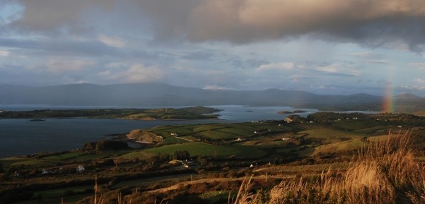
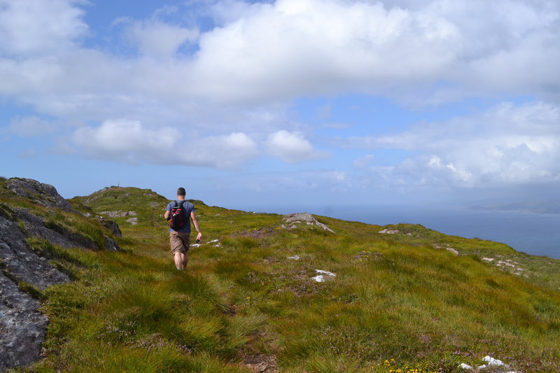
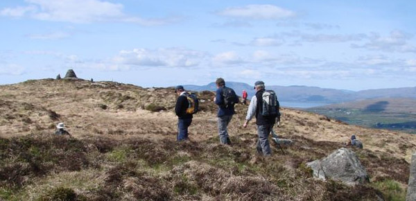
The Sheep’s Head Way walking route is renowned as one of the most spectacular walking routes in Europe. It brings along the coastline of the Sheep’s Head peninsula with Bantry Bay and Dunmanus Bay below you as you hike.

Take a guided walk along the Sheep’s Head Way with Hillside Walks and you’ll find out about the rich history of the Sheep’s Head peninsula as you explore a landscape marked with the traces of Ireland’s rich history. Take in the rugged beauty, and the fine views across the neighbouring West Cork peninsulas and islands. This unspoilt part of Ireland has been recognised as a European Destination of Excellence in recognition of its outstanding natural beauty.

Accommodation Packages

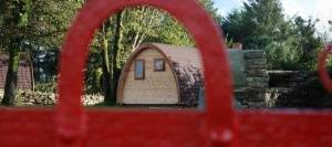
Our tours with experienced walking guide Charlie McCarthy can also be arranged to include accommodation at Seamount Farm B&B. Scenically set with interesting gardens, Seamount Farm B&B is a restored 7th-generation Irish farmhouse with traditional stone farm buildings. It’s the ideal base for a hill walking holiday in Ireland. The house boasts magnificent views overlooking Bantry Bay and across to the Beara peninsula.

If you would like to stay in different B&Bs during your visit, we can save you the worry of sourcing accommodation and arrange this for you. Guided walks can be arranged for all visitors to West Cork.

Location:Glenlough West
Bantry, Co. Cork
Owner:Charlie McCarthy
Tel:00 353 27 61226
Email:[email protected]
Website:http://www.sheepshead.ie/
Tripadvisor:No
Google Maps:No
Further information:All walks are priced individually and we offer discounts for groups - please ask us when making your booking. We operate throughout the year subject to weather conditions and availability.

Filed Under: Walking, Walking Guides, Walking Tours

Sheep’s Head Way Section 1: Bantry To Boolteenagh

January 18, 2015 by Dunmanus

Boolteenagh Sheep's Head Walk

The first section of the Sheep’s Head Way walking route leads you out onto the ridge of the Sheep’s Head peninsula

Set out from Bantry town along small lanes and fields to the first ridge section on the Sheep’s Head peninsula, a European destination of excellence.

Distance: 7.3km

IV 99318 48463
The Sheep’s Head Way starts in Wolfe Tone Square, Bantry. With the square and the statue of St.Brendan the Navigator (Naomh Bréanainn) behind you, looking towards Bantry Bay, take the N71 road that runs along the south (left) side of the bay. On the right, at the start of the quay is the Sheep’s Head Way information board and map. Post 001 is attached to a telegraph pole. Opposite, next to the road by the Cinemax cinema is the gatehouse to Bantry House. Go through the gate and follow the drive up to the house.

IV 98756 48181
Pass the house on either side. Just after the house turn to the right, down through the car park and leave through the main gates. The route from the west ends here – be sure to leave through the main entrance, and not through the gardens, or you will be heading off in the wrong direction! If Bantry House is closed, just stay on the main road to 006.

IV 98387 48153
Between a boatyard and a previous gatehouse for Bantry House, turn left into the grounds of the West Lodge Hotel. Follow the path past the ponds and up through the grounds and exit by the main entrance in front of the hotel car park. Cross the busy main road, turn to the left and at marker 5 take the first turn on the right signed ‘Dromclogh’. Follow this small road and you will soon be away from the hustle and bustle of the town.

IV 97650 47712
Turn left onto a smaller road which soon turns into a track and at 8 goes over a stile and along the edge of a field.

IV 96980 47366
Lady’s Well is still a place of local pilgrimage. From here follow the posts across the corner of a field and over a ladder stile onto a road. Follow this road to the T junction at 22 and turn left.

IV 95607 46494
Turn left onto the larger road and go carefully around the bend (I suggest you keep on the left to be seen).

Turn up the small road which will take you steeply up round many sharp bends to the ridge. On the way take a look back as there are several ring forts to be seen and there are good views over Whiddy Island and Bantry Bay.

V 95053 45240
The next section of the Sheep’s Head Way leads along the ridge to Glanlough.

Filed Under: Sheep's Head Way, Walking

Seefin Loop Walk

April 3, 2014 by Dunmanus

The Seefin loop walk leads you out along the ridge of the Sheep’s Head with spectacular views over Bantry Bay, Dunmanus Bay, and the ridge of the peninsula

The route climbs up to the ridge of the peninsula, and rewards you as you walk with views over Kilcrohane, our West Cork bays, the Mizen and Beara peninsulas and the West Cork islands in Bantry and Roaringwater bays.

The chance to reward yourself with a fine feast, or a drink overlooking Kitchen Cove at Ahakista‘s Arundel’s By the Pier isn’t to be missed at the end of your journey.

seefin loop walk Sheep's Head peninsula

Seefin Loop Walk Details

From the car park at Arundel’s by the Pier, take a right onto the public road and continue on until you arrive at a tee junction (Ahakista Bridge).

Take a right here and then the first left as per the finger post sign and follow the blue arrows for Seefin. At the next finger post sign keep left and follow the blue arrows for Seefin in a northwesterly direction and at way marker no. 9 (Seefin) continue straight on along the track.

When you arrive at way marker no. 10 for Seefin take a left and follow the blue arrows in a southwesterly direction until you reach way marker no. 21 for Seefin. Take a right here and continue on in a northerly direction.

At The Windy Gap Junction sign (way marker no. 165) take the Seefin/Kilcrohane option keeping left in a southwesterly direction for the summit of Seefin. When you reach the top take a sharp left at the Trig Point/way marker no. 41.

Descend following the blue arrows and continue through to a farmyard. At way marker no. 64 you will go off road and then pass an old “Cillín” (little church or burial ground) and a fort on your way. At way marker no. 76 continue on down until you reach way marker no. 92 on the old Kilcrohane/Ahakista road. Take a left here and continue straight on along the old road.

You will eventually arrive onto a tarred road, passing by the Átha Thomáis memorial em route to the main public road. This will lead you back to Ahakista bridge and the car park at Arundel’s by the Pier.
 

Download GPX Files for GPS Devices:Download Seefin Loop Walk GPX file
Download File for 3D View in Google Earth:Download Seefin Loop Walk KMZ file
Start/Finish:Ahakista Trailhead: Arundels by the Pier car park.
Grade:Hard
Distance:12.1 km (approx)
Estimated Time:4hrs 15 mins (based on average walking speed of 3km per hour)
Arrows:Blue
Metres Climbed/ Ascent:475 metres
Maximum Height:345 metres
Dogs Allowed?No
Minimum Gear:Walking boots, rain gear, fluid, and a mobile phone.

Filed Under: Sheep's Head Way Loop Walks, Ahakista Trailhead, Hard, Walking

Gortnakilly Loop Walk | Sheep’s Head Way

February 5, 2014 by Dunmanus

Take the Gortnakilly Loop Walk on the north side of the award-winning Sheep’s Head peninsula and enjoy stunning views across Bantry Bay

From the car park at Dún Óir on the north side of the peninsula, go over the timber stile way marker, Christian Cross no. 1. Follow the Mass Path way markers uphill until you reach The Mass Path Junction sign/ way marker no. 151.

Take the Sheep’s Head Way West Barán/Seefin option. Continue on until you reach The Windy Gap Junction sign/way marker no. 165 and take the Sheep’s Head Way West via the Goat’s Path option. Continue on down until you reach way marker no. 178.

At this point you will be walking down in a generally northerly direction until you meet the public road at way marker no. 190. Take a right turn here, and continue along the public road in a northeasterly direction and back to the car park at Dún Óir.
 

Download GPX file for GPS devices:File for Gortnakilly Loop Walk route
Start/Finish:Dún Óir Trailhead
Grade:Hard
Distance:7.9 km (approx)
Estimated time:2 hrs 45 mins (based on average walking speed of 3 km per hour)
Arrows:Orange arrows and follow the Mass Path Way markers (Christian Cross Symbol) until way marker no. 151. Then follow the main Sheep's Head Way yellow man markers.
Metres Climbed/ Ascent:302 metres
Maximum Height:270 metres
Dogs Allowed?No
Minimum Gear:Walking boots, rain gear, fluid, and a mobile phone.
Download file for 3D View on Google Earth:KMZ file for Gortnakilly Loop Walk route

Filed Under: Dún Óir Trailhead, Estimated Time: Under 3 hours, Hard, Sheep's Head Way Loop Walks, Walking

Cahergal Loop Walk

February 3, 2014 by Dunmanus

The Cahergal Loop Walk on the Sheep’s Head peninsula introduces you to the beauty and peace of an area recognised as a European Destination of Excellence

From the car park at the Black Gate and Alice West Centre past the village of Kilcrohane, follow the purple loop walk arrows for the Cahergal Loop Walk in a northeasterly direction along the public road for a short distance.

At way marker no. 3 (Peakeen, Cahergal and Caher), turn left off the public road. Continue up the track and onto the hill going through 4 stiles en-route until you reach way marker no. 15 (Peakeen and Cahir) and turn left.

Continue on, crossing the peninsula to the Bantry Bay side, until you reach the car park at Cahergal. Keep left after going over the timber stile and cross the road where you will go over another timber stile, passing way marker no. 206.

Continue straight on for the cove, passing the the ruins of a famine hamlet known locally as the “Crimea” and the abandoned copper mines, en route. At way marker no. 238, keep left and walk a short distance along the pubic road. Turn right at the finger post sign for “The Poet’s Way” and go off-road over a timber stile, at way marker no. 65 Poet’s Way/Cahergal. Follow the way markers to traverse the peninsula to the south side until you meet way marker no. 348.

Turn left here and continue straight on until way marker no. 354 and turn right. Continue on down to the public road and back to the Black Gate / Alice West Centre.
 

Download GPX file for GPS:Download Cahergal Loop Walk GPX file
Download file for 3D View on Google Earth:Download Cahergal Loop Walk KMZ file
Start/Finish:Black Gate Trailhead
Grade:Hard
Distance:8.4 km (approx)
Estimated Time:3 hrs (based on average walking speed of 3 km per hour)
Arrows:Purple
Metres Climbed/ Ascent:371 metres
Maximum Height:184 metres
Dogs Allowed?No
Minimum Gear:Walking boots, rain gear, fluid, and a mobile phone.

Filed Under: Black Gate trailhead, Estimated Time: Under 3 hours, Hard, Kilcrohane, Sheep's Head Way Loop Walks, Walking

Caher Loop Walk | Sheep’s Head Way

February 3, 2014 by Dunmanus

The Caher Loop Walk leads you up to the ridge of the Sheep’s Head peninsula, with fine views over Bantry Bay and Dunmanus Bay!

From the car park at the Black Gate / Alice West Centre just outside Kilcrohane village, follow the green loop walk arrows in a northeasterly direction along the public road for a short distance.

At way marker no. 3 (Peakeen, Cahergal and Cahir) turn left off the public road. Continue up the track and onto the hill going through 4 stiles en route until you reach way marker no. 17 marked Peakeen/Cahir.

Turn right down the hill beyond Cahir lake on an old road. When this road meets the public road turn left. Walk along the public road for a short distance then turning right downhill again onto “the stony roadeen” passing by a private garden.

Next veer right onto the public road again for a considerable distance. At way marker no. 368, veer right again walking in a southwesterly direction on the public road passing “The Cill” at Caher, a famine graveyard en route. The loop enters farmland at way marker no. 366 and descends towards the sea.

At Trá Rúaim strand, veer right uphill on the public by-road and right again when this road meets the main public road to return to The Black Gate.
 

Download GPX file for GPS:Download Caher Loop Walk GPX file
Download File for 3D View on Google Earth:Download Caher Loop Walk KMZ file
Start/Finish:Black Gate Trailhead
Grade:Hard
Distance:5.6 km (approx)
Estimated Time:2 hrs (based on average walking speed of 3 km per hour)
Arrows:Green Arrows
Metres Climbed/ Ascent:210 metres
Maximum Height:189 metres
Dogs Allowed?No
Minimum Gear:Walking boots, rain gear, fluid, and a mobile phone.

Filed Under: Black Gate trailhead, Estimated Time: Under 3 hours, Hard, Sheep's Head Way Loop Walks, Walking

  • 1
  • 2
  • 3
  • …
  • 8
  • Next Page »
Wild Atlantic Way

What’s On

May 2023
The Sheep's Head Challenge
May 13 2023

Sheep’s Head Challenge 2023

June 2023
West Cork Chamber Music Festival
Jun 23 2023 - Jul 02 2023

West Cork Chamber Music Festival

July 2023
West Cork Literary Festival
Jul 07 - 14 2023

West Cork Literary Festival

Bantry
August 2023
Masters of Tradition Festival
Aug 23 - 27 2023

Masters of Tradition: A Traditional Music Festival

Bantry
No event found!

Visit Historic Places

Bantry House B&B

The Sheep’s Head is a peninsula rich in history and you’ll find traces of its past all along the Sheep’s Head Way walking route.

Find out more

Pure cork

Featured Activity

Darren's Kayaks West Cork

Darren’s Kayaks

Kayak on the peaceful and sheltered waters of West Cork’s Dunmanus Bay with Darren’s Kayaks and explore the scenic coastline of the stunning Sheep’s Head peninsula Whether you want a relaxing paddle taking in the scenery and wildlife of the beautiful Sheep’s Head coastline or a fast-paced fun ‘Pier to Mannion Island’ time trial, we […]

More Activities

Featured Accommodation

Blairscove Accommodation

Blairscove House

Surrounded by 4.5 acres of lawns and gardens, in West Cork, Blairscove House and restaurant is the ideal place to spend a few relaxing days Since 1972, Blairscove has remained in the hands of the same family; and Philippe and Sabine De Mey, the present owners, continue to provide top quality dining and accommodation. The […]

More Accommodation

This project has been supported by Cork County Council & the LEADER programme under the Rural Development Programmes 2007-13 and 2017-2021.
  • The Sheep’s Head Way
  • Loop Walks
  • Accommodation
Sheep's Head & Bantry Tourism Cooperative, copyright 2018 | Website by Wordhoard Communications