Living the Sheep's Head Way

  • The Sheep’s Head Way
  • Loop Walks
  • Accommodation
    • B&Bs
    • Hotels
    • Farmhouse Accommodation
    • Campsites

MENUMENU
  • Home
  • Things to Do
    • Walking
      • Sheep's Head Way Main Route
      • Loop Walks
        • Difficulty
          • Easy
          • Moderate
          • Hard
        • Time
          • Under 3 hours
          • 3-5 hours
          • 5 hours or more
        • Trailheads
          • Ahakista
          • Bantry West
          • Black Gate
          • Dún Óir
          • Durrus
          • Goat's Path
          • Kilcrohane
          • Tooreen
          • Whiddy Island
      • Walking Guides
    • Courses & Training
    • Crafts
    • Culture
    • Gardens
    • History
    • Cycling
    • Pony Trekking
    • Sailing & Kayaking
  • What's On
    • Events
    • Scheduled Courses
    • Festivals
  • Food
    • Cafés
    • Restaurants
    • Food Producers
    • Food Tours
    • Coeliac-Friendly
  • Where to Stay
    • B&B
    • Hotels
    • Self-Catering Holiday Homes
    • Farmhouse Accommodation
    • Campsites
    • Luxury Accommodation
    • Accessible Accommodation
  • News
  • How to Get Here
  • Location
    • Map
    • Ahakista
    • Bantry
    • Ballylickey
    • Drimoleague
    • Durrus
    • Kilcrohane
    • Whiddy Island
  • Services
    • Shops
    • Taxi Services
  • Contact Us
You are here: Home / Archives for Sheep's Head Way Loop Walks

Sheep’s Head Loop Walks

January 29, 2016 by Dunmanus

Boolteenagh Sheep's Head Loop Walks West Cork Ireland

The Sheep’s Head Loop Walks in West Cork give you a marvellous introduction to the coastal walks and lush farmland along our Wild Atlantic walking trails

Explore the Sheep’s Head peninsula – a European Destination of Excellence – Whiddy Island, and the lush farmland around Bantry and Drimoleague.

Easy to Follow Walking Trails

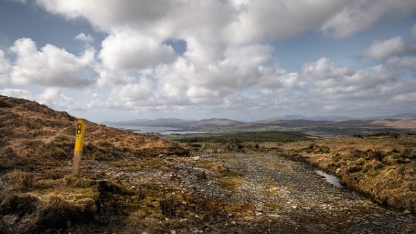
All of the stunning Sheep’s Head loop walks are colour-coded, and so each route is easy to follow. The self-guided walker can choose from a great variety of rewarding walking experiences. West Cork walking guides are also available, and scheduled walks can be found on our event calendar.

Each of the Sheep’s Head loop walks will take you between one and seven hours to complete. We offer you full details about the length and difficulty of each loop walk on each walk’s page so that you can choose the walking trail best suited to you. The Sheep’s Head loop walks radiate from trailheads at Drimoleague, Bantry, Ahakista, Kilcrohane, Black Gate, and Tooreen near the tip of the Sheep’s Head peninsula.

The walks invite you to explore the Sheep’s Head peninsula – a European Destination of Excellence – and give you a taste of what it is like to walk the complete Sheep’s Head Way around the peninsula’s unspoilt coastline.

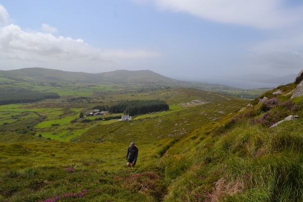
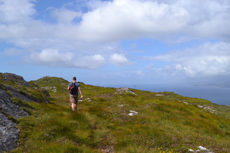
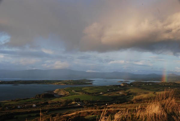
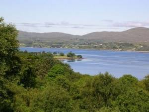
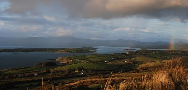
At every turn, you’ll find spectacular views across Dunmanus Bay, Bantry Bay, the West Cork islands, and our neighbouring Mizen and Beara peninsulas.

Sheep's Head Way Loop Walks

The Eastern Trails

On the eastern side, the Sheep’s Head Way extends to Drimoleague, Mealagh, Kealkill and Carriganass Castle, linking up with the Beara-Breifne Way en route to Gougane Barra. The inland loop walks provide new pleasures as the rolling hills and lush farmland of West Cork come into view.

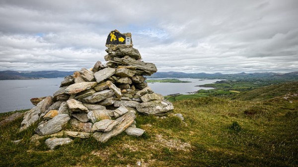
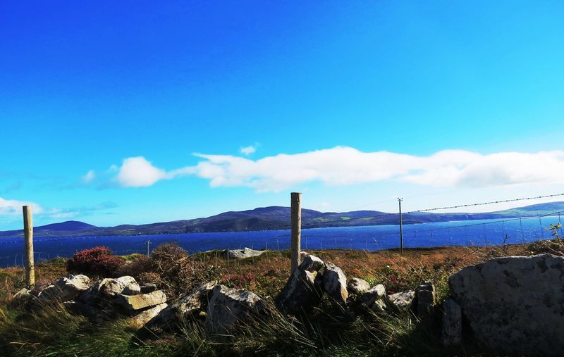
Take the iconic walk to the Sheep’s Head Lighthouse. Walk the Peakeen Ridge, or enjoy the beauty of the Coomkeen Walk (pictured). There’s great variety here for hikers of all abilities.

As you explore the West Cork landscape, you’ll find numerous monastic, archaeological and historical sites. Take in views across Sheep’s Head lakes, blowholes, the West Cork islands and the expanse of the Atlantic Ocean as it stretches towards America.

This area is predominantly a Special Area of Conservation (SAC) and National Heritage Area (NHC). In 2009, the Sheep’s Head Way was recognised as a European Destination of Excellence (EDEN) and the award recognises the high-quality and sustainable tourism on offer in this beautiful part of Ireland.

Walk the Sheep’s Head Way and start to explore one of the most scenic places in Ireland!

Filed Under: Sheep's Head Way Loop Walks

Coomkeen Loop Walk | Sheep’s Head Way

August 23, 2014 by Dunmanus

Coomkeen Sheep's Head Loop Walk West Cork

From the ridge of the Sheep’s Head peninsula, the Coomkeen Loop Walk offers wonderful views

Look out over Whiddy Island, Bantry Bay, and the Beara peninsula. And take in views along the peninsula before heading down to walk quiet country lanes in the fertile valley where Durrus Cheese is made.

Coomkeen Loop Walk Sheeps Head peninsula West Cork

Coomkeen Loop Walk Route

To begin the Coomkeen Loop Walk, drive from Durrus village taking the main road for Kilcrohane and after St. James’s Church of Ireland take the first right, continue on until you reach a crossroads and take the option for Coomkeen (straight on). This road will take you all the way to the car park at Boolteenagh.

From the car park at Boolteenagh, way marker no. 31 set out off road in a southwesterly direction along the ridge before you reach way marker no. 49 you will see “Lough Na Fuilla” (Lake of the Blood) straight ahead of you. Turn left here after crossing over a timber stile, way marker 20 CM.

Follow a track (The old lake road) in a southerly direction which will eventually lead onto a tarred road. Go straight on here at way marker no. 16 CM, past the junction for Fahane and Gerahies until you reach a finger post sign for “Coomkeen”. Take a left here and continue along the road again until you reach two more sets of finger post signs, take the “Coomkeen Loop option at each. Continue back to the car park at Boolteenagh along the road, passing the turn off for “Durrus Cheese” enroute.

Note : Be aware of weather conditions and cut away peat bogs along the loop walk. Please do not exit marked trails only on marked routes. No dogs are allowed on The Sheep’s Head Way.

The Coomkeen Loop Walk is one of 20 colour-coded Sheep’s Head Way loop walks.

Download GPX File:Coomkeen Loop GPX File
View the route in 3D on Google Earth:Download Coomkeen Loop Walk KMZ file
Start/Finish:Durrus Trailhead and drive to the Boolteenagh car park.
Grade:Easy
Arrow Colour:Follow the orange arrows & yellow 'walking man' markers
Distance:6.8 km (approx)
Estimated time:2 hours 30 mins (based on average walking speed of 3 km per hour)
Metres Climbed/ Ascent:433 metres
Maximum Height:222 metres
Dogs Allowed?No
Minimum Gear:Walking boots, rain gear, fluid, and a mobile phone.

Filed Under: Easy, Durrus, Durrus Trailhead, Estimated Time: Under Three Hours, Sheep's Head Way Loop Walks

Mount Corrin Loop Walk | Sheep’s Head Way

August 21, 2014 by Dunmanus

Mount Corrin Loop Walk c PeterClarke

The Mount Corrin Loop Walk is a six-hour hike on the Sheep’s Head Way that rewards you with gorgeous views over West Cork’s hills and Dunmanus Bay

It’s dotted with sights of historic interest too, from cairns to megalithic tombs. Well worth the effort!

“The views from the cairn are stupendous, taking in the West Cork peninsulas and the hinterland across to the Kerry mountains.” (Roaringwater Journal)

Mount Corrin Loop Walk Sheep's Head Way near Durrus

Mount Corrin Loop Walk Route

To begin the Mount Corrin Loop Walk on West Cork’s Sheep’s Head peninsula, set out from Durrus village along the old creamery road passing Wiseman’s hardware store on your way.

The well-signposted walk is part of the Sheep’s Head Way hiking route on Ireland’s southwest coastline.

Continue on along the road for a good while until you reach way marker no. 570 on a telephone pole, take a right here and go up another road. At way marker no. 572 you will go off road and through farm land and tracks until you will arrive at a timber stile, way marker no. 600 and a gate with an information sign on it. Go right after going over the timber stile and continue along the road until you reach another timber stile, way marker no. 603. Go left over the timber stile and onto the land, continue on up until you reach way marker no. 619 and take the Mount Corrin option which is straight on ahead and over a timber stile.

Continue on up along. Further on down, you will reach an information sign beside the road and take the Mount Corrin/Dunbeacon option. Across the road you will see way marker no. 397 and from here you will set out for Mount Corrin. On reaching the summit you will descend down onto the Mine Road via a timber stile way marker no. 975. (There is an information sign here also at this point, so you can opt for going back to Durrus village or the car park at Dunbeacon Church).

Take a right here along the road and continue on until way marker no. 976 on a telephone pole, if you want to go to the car park at Dunbeacon Church turn left here and the road will lead you there.

Continue down the Mines Road. (To the left is a marked path to the Dunbeacon Stone Circle if you wish to visit it, adding about 1km to the route. A short distance further on, to the left, is a short path to the Coolcoulaghta Stone Row).

Just before the Mines Road meets the R591 road to Durrus, look out for a stile on the left. This will take you across fields and a boreen to another small road where you turn right. Follow this road to the T-junction where you turn left and then left again at the next junction before turning right onto the R591 road which will lead you back to Durrus village from where you started.

Note : Be aware of weather conditions and cut away peat bogs along the loop walk. Be aware of any livestock on the land, especially any bulls. Please do not exit marked trails. Stay on marked routes, and remember that no dogs are allowed on the Sheep’s Head Way.

The Mount Corrin Loop Walk is one of 20 colour-coded Sheep’s Head Way loop walks.

Plan your visit here at https://livingthesheepsheadway.com

Download GPX FileDownload Mount Corrin Loop Walk GPX file
View Route in 3D on Google Earth:Download Mount Corrin Loop Walk KMZ file
Start/Finish:Durrus Trailhead or Dunbeacon Church car park.
Grade:Hard
Arrows:Follow the purple arrows & yellow 'walking man' markers
Distance:17.1 km (approx)
Estimated time:6 hours (based on average walking speed of 3 km per hour)
Metres Climbed/ Ascent:585 metres
Maximum Height:301 metres
Dogs Allowed?No
Minimum Gear:Walking boots, rain gear, fluid, and a mobile phone.

Filed Under: Durrus, Durrus Trailhead, Estimated Time: 5 hours or more, Hard, Level: Hard, Sheep's Head Way Loop Walks

Seefin Loop Walk

April 3, 2014 by Dunmanus

The Seefin loop walk leads you out along the ridge of the Sheep’s Head with spectacular views over Bantry Bay, Dunmanus Bay, and the ridge of the peninsula

The route climbs up to the ridge of the peninsula, and rewards you as you walk with views over Kilcrohane, our West Cork bays, the Mizen and Beara peninsulas and the West Cork islands in Bantry and Roaringwater bays.

The chance to reward yourself with a fine feast, or a drink overlooking Kitchen Cove at Ahakista‘s Arundel’s By the Pier isn’t to be missed at the end of your journey.

seefin loop walk Sheep's Head peninsula

Seefin Loop Walk Details

From the car park at Arundel’s by the Pier, take a right onto the public road and continue on until you arrive at a tee junction (Ahakista Bridge).

Take a right here and then the first left as per the finger post sign and follow the blue arrows for Seefin. At the next finger post sign keep left and follow the blue arrows for Seefin in a northwesterly direction and at way marker no. 9 (Seefin) continue straight on along the track.

When you arrive at way marker no. 10 for Seefin take a left and follow the blue arrows in a southwesterly direction until you reach way marker no. 21 for Seefin. Take a right here and continue on in a northerly direction.

At The Windy Gap Junction sign (way marker no. 165) take the Seefin/Kilcrohane option keeping left in a southwesterly direction for the summit of Seefin. When you reach the top take a sharp left at the Trig Point/way marker no. 41.

Descend following the blue arrows and continue through to a farmyard. At way marker no. 64 you will go off road and then pass an old “Cillín” (little church or burial ground) and a fort on your way. At way marker no. 76 continue on down until you reach way marker no. 92 on the old Kilcrohane/Ahakista road. Take a left here and continue straight on along the old road.

You will eventually arrive onto a tarred road, passing by the Átha Thomáis memorial em route to the main public road. This will lead you back to Ahakista bridge and the car park at Arundel’s by the Pier.
 

Download GPX Files for GPS Devices:Download Seefin Loop Walk GPX file
Download File for 3D View in Google Earth:Download Seefin Loop Walk KMZ file
Start/Finish:Ahakista Trailhead: Arundels by the Pier car park.
Grade:Hard
Distance:12.1 km (approx)
Estimated Time:4hrs 15 mins (based on average walking speed of 3km per hour)
Arrows:Blue
Metres Climbed/ Ascent:475 metres
Maximum Height:345 metres
Dogs Allowed?No
Minimum Gear:Walking boots, rain gear, fluid, and a mobile phone.

Filed Under: Sheep's Head Way Loop Walks, Ahakista Trailhead, Hard, Walking

Barnageehy Loop Walk | Sheep’s Head Way

February 5, 2014 by Dunmanus

Barnageehy Loop Walk on the Sheep’s Head Way is a peaceful walk through gorgeous Irish countryside

You’ll enjoy the wonderful views over patchwork fields and moorlands as you walk you walk the quiet roads around Durrus and explore country tracks with views over Bantry and the West Cork hills.

Barnageehy Loop Walk Details

To begin the Barnageehy Loop Walk, drive from Durrus village to the Car Park at Barnageehy.

Take the old creamery road from Durrus, passing Wiseman’s Hardware Store, and continue on along this road until you reach the N71 and take a right here.

The N71 will take you all the way uphill until you reach the car park at Barnageehy. At the Sheep’s Head Way finger post sign, turn right into the car park. There is a sign for Glanlough there also.

To reach Barnageehy from Bantry, drive from Bantry taking the N71 passing The Westlodge Hotel and the turn off for The Sheep’s Head peninsula en route. Turn right at the junction for Skibbereen and Ballydehob and the N71 will take you all the way uphill until you reach the car park at Barnageehy. At the Sheep’s Head Way finger post sign turn in to your right to the car park, there is a sign for Glanlough there also.

From the car park at Barnageehy set out along the road in a westerly direction following the yellow walking man way markers. At way marker no. 634 turn left off road and continue on up a track in a southerly direction at first before heading in a southwesterly direction with forestry on your left as you ascend. When you reach way marker no. 619, turn right here to descend down to the public road going over a timber stile, way marker no. 603. Turn right here and follow the road back to the car park at Barnageehy passing by a timber stile, way marker no. 600 and a gate with an information sign on it enroute.

Note : Be aware of weather conditions and cut away peat bogs along the loop walk. Be aware of any livestock on the land, especially any Bulls. Please do not exit marked trails only on marked routes. No dogs are allowed on the Sheep’s Head Way.

The Barnageehy Loop Walk is one of 20 colour-coded Sheep’s Head Way loop walks.

Download GPX File for GPS:Barnageehy Loop Walk file
View in 3D on Google Earth:Download Barnageehy Loop Walk file
Start/Finish:Durrus Trailhead and drive to the Barnageehy car park.
Grade:Moderate
Arrow Colour:Follow the green arrows & yellow 'walking man' markers
Distance:7.7 km (approx)
Estimated time:2 hours 45 mins (based on average walking speed of 3 km per hour)
Metres Climbed/ Ascent:546 metres
Maximum Height:301 metres
Dogs Allowed?No
Minimum Gear:Walking boots, rain gear, fluid, and a mobile phone.

Filed Under: Durrus Trailhead, Durrus, Estimated Time: Under Three Hours, Moderate, Sheep's Head Way Loop Walks

Rooska Loop Walk | Sheep’s Head Way

February 5, 2014 by Dunmanus

Starting in the heart of Bantry town, the Rooska Loop Walk takes you out into the West Cork countryside where spectacular views await

The route passes Bantry House, ringforts, ruined farms, and a holy well. The views out over Bantry Bay and Whiddy Island are lovely to behold. From the bustle of Bantry square to the green trails of the Sheep’s Head peninsula, this is an absorbing and satisfying West Cork walk.

Boolteenagh Sheeps Head - Rooska Loop Walk Bantry

Rooska Loop Walk Details

To complete the Rooska Loop Walk, set out from the Bantry West trailhead, set out along the N71 and, at way marker no. 1, turn left and continue along until stone way marker no. 678 (on back of stone) and turn right taking the north option.

When you reach the N71 again keep left and continue on again for a short distance until you go off road at way marker no. 4. When you arrive again onto the N71, take the option for ‘Dromclogh’ at the finger post sign (way marker no. 5) after crossing the road.

Continue on along the road again until way marker no. 6 and turn left off the road. You will stay off road until way marker no. 22. Follow the road along until way marker no. 25 and turn left. Continue on up the road, and at the T-junction, take a right as per the finger post sign for Boolteenagh, way marker no. 26.

Continue along until you reach the car park at Boolteenagh. At way marker no. 31 set out off road in a southwesterly direction along the ridge passing Lough Na Fuilla (Lake of the Blood) on your left before you reach way marker no. 49. Turn right here and follow a track (the old lake road) in a northwesterly direction which will eventually lead onto a tarred road at way marker no. 2.

Continue down along the road until it meets the main public road at way marker no. 1 (the finger post sign for Lough na Fuilla and Rooska West) and turn right. Keep along the main road until you reach way marker no. 25 to complete the loop.

From here on follow the way markers back to where you came from and you will eventually arrive at the Bantry West trailhead.
 
The Rooska Loop Walk is one of 20 colour-coded Sheep’s Head Way loop walks.

GPX File for GPS:Download GPX file for Rooska Loop Walk
View 3D in Google Earth:Download KMZ file for Rooska Loop Walk
Start/Finish:Bantry West Trailhead
Grade:Moderate
Distance:13.9 km (approx)
Estimated time:4 hours 45 mins (based on average walking speed of 3 km per hour)
Arrows:Purple
Metres Climbed/ Ascent:433 metres
Maximum Height:222 metres
Dogs Allowed?No
Minimum Gear:Walking boots, rain gear, fluid, and a mobile phone.

Filed Under: Bantry West Trailhead, Bantry, Estimated Time: 3-5 hours, Moderate, Sheep's Head Way Loop Walks

  • 1
  • 2
  • 3
  • Next Page »

Leave No Trace

Practising a Leave No Trace ethic is very simple: make it hard for others to see or hear you and leave no trace of your visit.

• plan ahead and prepare
• be considerate of others
• respect farm animals and wildlife
• leave what you find
• camp on approved sites or with landowners' permission
• dispose of waste properly

Please do not exit marked trails: walk only on marked routes. No dogs are allowed on The Sheep’s Head Way.

Transport & Taxi Services

If you need local transport to and from your walk, taxi services are available from the following local companies:

* Jack McNulty (Durrus) Tel: +353 (0) 27 61219
Mobile: +353 (0) 87 784 5939

* Liam Ward- Ward's Hackney Carriages
(Durrus) Tel: +353 (0)27 61 476
Mobile: +353 (0)86 855 6189

Regular bus services run from Cork to Bantry.
For details see http://buseireann.ie>

Bantry Bay Adventure Race (25 August 2018)

Bantry Bay Adventure Race

Featured Activity

Culture Kitchen Food Tours

Manning’s Emporium Food Tours

Manning’s Emporium Food Tours brings you to the very heart of West Cork’s foodie culture with its absorbing day tours If you love the local food you’re tasting along the Wild Atlantic Way, take a Manning’s Emporium foodie tour and you’ll discover how the spirit of West Cork infuses the flavours on your plate. Each […]

More Activities

Featured Accommodation

Pondlodge Cottages

Pondlodge Cottages

Enjoy a self-catering holiday at the Pondlodge Cottages in the beautiful grounds of Bantry’s Westlodge Hotel These nine self-catering holiday cottages are set in beautifully landscaped gardens in the scenic surroundings of Bantry, County Cork. The hotel, which is just a short stroll away, boasts dining options, a health and leisure centre, therapeutic treatments and […]

More Accommodation

This project has been supported by Cork County Council & the LEADER programme under the Rural Development Programmes 2007-13 and 2017-2021.
  • The Sheep’s Head Way
  • Loop Walks
  • Accommodation
Sheep's Head & Bantry Tourism Cooperative, copyright 2018 | Website by Wordhoard Communications