Living the Sheep's Head Way

  • The Sheep’s Head Way
  • Loop Walks
  • Accommodation
    • B&Bs
    • Hotels
    • Farmhouse Accommodation
    • Campsites

MENUMENU
  • Home
  • Things to Do
    • Walking
      • Sheep's Head Way Main Route
      • Loop Walks
        • Difficulty
          • Easy
          • Moderate
          • Hard
        • Time
          • Under 3 hours
          • 3-5 hours
          • 5 hours or more
        • Trailheads
          • Ahakista
          • Bantry West
          • Black Gate
          • Dún Óir
          • Durrus
          • Goat's Path
          • Kilcrohane
          • Tooreen
          • Whiddy Island
      • Walking Guides
    • Courses & Training
    • Crafts
    • Culture
    • Gardens
    • History
    • Cycling
    • Pony Trekking
    • Sailing & Kayaking
  • What's On
    • Events
    • Scheduled Courses
    • Festivals
  • Food
    • Cafés
    • Restaurants
    • Food Producers
    • Food Tours
    • Coeliac-Friendly
  • Where to Stay
    • B&B
    • Hotels
    • Self-Catering Holiday Homes
    • Farmhouse Accommodation
    • Campsites
    • Luxury Accommodation
    • Accessible Accommodation
  • News
  • How to Get Here
  • Location
    • Map
    • Ahakista
    • Bantry
    • Ballylickey
    • Drimoleague
    • Durrus
    • Kilcrohane
    • Whiddy Island
  • Services
    • Shops
    • Taxi Services
  • Contact Us
You are here: Home / Archives for Estimated Time: 3-5 hours

Rooska Loop Walk | Sheep’s Head Way

February 5, 2014 by Dunmanus

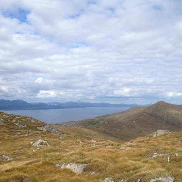
Starting in the heart of Bantry town, the Rooska Loop Walk takes you out into the West Cork countryside where spectacular views await

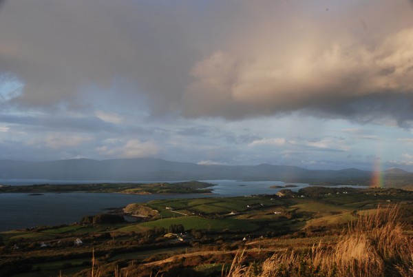
The route passes Bantry House, ringforts, ruined farms, and a holy well. The views out over Bantry Bay and Whiddy Island are lovely to behold. From the bustle of Bantry square to the green trails of the Sheep’s Head peninsula, this is an absorbing and satisfying West Cork walk.

Boolteenagh Sheeps Head - Rooska Loop Walk Bantry

Rooska Loop Walk Details

To complete the Rooska Loop Walk, set out from the Bantry West trailhead, set out along the N71 and, at way marker no. 1, turn left and continue along until stone way marker no. 678 (on back of stone) and turn right taking the north option.

When you reach the N71 again keep left and continue on again for a short distance until you go off road at way marker no. 4. When you arrive again onto the N71, take the option for ‘Dromclogh’ at the finger post sign (way marker no. 5) after crossing the road.

Continue on along the road again until way marker no. 6 and turn left off the road. You will stay off road until way marker no. 22. Follow the road along until way marker no. 25 and turn left. Continue on up the road, and at the T-junction, take a right as per the finger post sign for Boolteenagh, way marker no. 26.

Continue along until you reach the car park at Boolteenagh. At way marker no. 31 set out off road in a southwesterly direction along the ridge passing Lough Na Fuilla (Lake of the Blood) on your left before you reach way marker no. 49. Turn right here and follow a track (the old lake road) in a northwesterly direction which will eventually lead onto a tarred road at way marker no. 2.

Continue down along the road until it meets the main public road at way marker no. 1 (the finger post sign for Lough na Fuilla and Rooska West) and turn right. Keep along the main road until you reach way marker no. 25 to complete the loop.

From here on follow the way markers back to where you came from and you will eventually arrive at the Bantry West trailhead.
 
The Rooska Loop Walk is one of 20 colour-coded Sheep’s Head Way loop walks.

GPX File for GPS:Download GPX file for Rooska Loop Walk
View 3D in Google Earth:Download KMZ file for Rooska Loop Walk
Start/Finish:Bantry West Trailhead
Grade:Moderate
Distance:13.9 km (approx)
Estimated time:4 hours 45 mins (based on average walking speed of 3 km per hour)
Arrows:Purple
Metres Climbed/ Ascent:433 metres
Maximum Height:222 metres
Dogs Allowed?No
Minimum Gear:Walking boots, rain gear, fluid, and a mobile phone.

Filed Under: Bantry West Trailhead, Bantry, Estimated Time: 3-5 hours, Moderate, Sheep's Head Way Loop Walks

Peakeen Ridge Loop Walk | Sheep’s Head Way

February 3, 2014 by Dunmanus

The Peakeen Ridge Loop Walk begins above Kilcrohane on West Cork’s Sheep’s Head peninsula

It’s a gorgeous walk out along the ridge of the Sheep’s Head. At every time of year, you’ll find something to delight the eye as you look across bays, moorland and lush green valleys. The walk is a perfect introduction to Ireland’s Wild Atlantic Way walks!

Look out for a passage tomb and a Mass Rock along your route. Why not call down to the village of Kilcrohane after your walk for dinner at The Old Creamery, or a visit to the Sheep’s Head Producer’s Shop?

Peakeen Ridge Loop Walk Sheep's Head Way

Peeakeen Ridge Loop Walk Details

Begin your walk behind the Pietà statue, and follow a route that leads you along the ridge of the Sheep’s Head peninsula, with spectacular views out over Dunmmanus Bay, the Mizen peninsula, and the Fastnet Rock to the east. To the west, you’ll see Bantry Bay, Beara, Bere Island, and even the Bull Rock on a clear day.

From the car park at the top of the Goat’s Path, follow the orange arrows and orange ‘walking man’ way markers heading in a southwesterly direction, passing behind the Pietà statue and marker no. 60 (Peakeen) as you go.

Continue on along the ridge passing a megalithic tomb en route. Further on you will descend the hill and almost straight away you will ascend another hill. Continue on along the ridge again until you will start to descend again at way marker no. 15 (Peakeen, Caher) veer right following the way markers for Cahergal.

As you go over the stile at the public road at Cahergal car park, keep right at way marker no. 205 and continue along the public road in a northeasterly direction. At the finger post sign for “Horse-shoe Road” and Finn McCool’s Seat near way marker 200.

Turn right here, and this track will take you back to the public road to way marker no. 194. Turn right here and the road takes you back to the car park at the top of The Goat’s Path.
 

Download GPX File for GPS:Download Peakeen Ridge Loop Walk GPX file
Download File for 3D View on Google Earth:Download Peakeen Ridge Loop Walk KMZ file
Start/Finish:Goat's Path trailhead.
Grade:Hard
Distance:11 km (approx)
Estimated Time:3 hrs 45 mins (based on average walking speed of 3 km per hour)
Arrows:Cream and red arrows
Metres Climbed/ Ascent:470 metres
Maximum Height:338 metres
Dogs Allowed?No
Minimum Gear:Walking boots, rain gear, fluid, and a mobile phone.
Facilities:Car Parking spaces available and bike rack.
Nearest village: Kilcrohane

Filed Under: Goat's Path Trailhead, Estimated Time: 3-5 hours, Hard, Kilcrohane, Sheep's Head Way Loop Walks, Walking

Poet’s Way Loop Walk | Sheep’s Head Way

January 15, 2014 by Dunmanus

The Poet’s Way Loop Walk on the Sheep’s Head Way is named for the poet Denis M. Cronin who was born in the townland of Eskeraha on the peninsula

His epic poem ‘The Chase of a Shadow’ was written in 1898 and salutes the beauty of this part of the world:

From pole to pole should my migration bend;
Or twice around the world should they extend,
No place in all those travels could be found,
To my mind’s eye, so adequately crowned
With nature’s diadems, serene, profuse,
At these romantic and unrivaled views.

The nearly 200-page narrative poem tells the story of Fergus, a young Irish aristocrat from The Sheep’s Head peninsula who is separated from his family, his country and his true love by Ireland’s 1798 rebellion.

For the modern hiker on the Poet’s Way Loop Walk, this loop walk takes you past dazzling inlets, coves, blow holes and sea arches along the way. You’ll also see a ruined 17th-century signal tower as you go, and the summit of Ballyroon Mountain provides spectacular views over Bantry Bay, Dunmanus Bay, and the Mizen and Beara peninsulas.

Poet’s Way Loop Walk Route

From the car park at Tooreen follow the red loop walk arrows. Set out in a southwesterly direction on the Dunmanus Bay side of the peninsula to the lighthouse passing Lough Akeen en route.

After the helicopter pad, the Sheep’s Head lighthouse comes into view and if you wish you can climb the concrete steps that lead up to it!

The loop returns on the Bantry Bay side, and at the Daingean sign near way marker no. 272 continue straight along the main route. At way marker no. 238 veer right and walk a short distance along the public road. Turn right at the finger post sign for “The Poet’s Way” and go off road over a timber stile, way marker no. 65 Poet’s Way/Cahergal.

Follow the way markers to traverse the peninsula to the south side until you meet way marker no. 348. At this way marker turn right and continue on along in a southwesterly direction. You will then descend downhill and go over a timber stile and onto the road.

Turn left here along the road for a short distance passing the “Fáilte Faill Bheag” sign on your way. At way marker no. 337 turn right up a tarred road and onto a track. Continue on passing the ruins of an old signal tower and a World War Two look out post further on, until you will descend and return back to the car park at Tooreen.
 
Note: Be aware of weather conditions, unprotected dangerous cliffs and cut away peat bogs along the loop walk. Be aware of any livestock on the land, especially any bulls. Please do not exit marked trails only on marked routes. No dogs are allowed on The Sheep’s Head Way.

Emergency: Phone 999 or 112 and state whether you need Ambulance, Gardaí (police), Fire Brigade or Mountain Rescue.

To identify your location on the Poet’s Way Loop walk, please quote the number of the nearest way marker pole or your GPS/grid co-ordinates.

LEAVE NO TRACE

• plan ahead and prepare
• be considerate of others
• respect farm animals and wildlife
• leave what you find
• camp on approved sites or with landowner’s permission
• dispose of waste properly

Practising a Leave No Trace ethic is very simple: make it hard for others to see or hear you and leave no trace of your visit.
 

Download GPX File for GPS:Download Poet's Way Loop Walk GPX file
Download File for 3D View on Google Earth:Download Poet's Way Loop Walk KMZ file
Start/End Point:Car park at the end of the road on the Sheep's Head peninsula.
Length:12.4 kilometres
Difficulty:Difficult
Estimated Time:4 hours 30 minutes (Based on average walking speed of 3km per hour)
Arrows:Red
Terrain:Paths, tracks, rocky trails, minor roads.
Ascent:462 metres
Max Height:239 metres
Facilities:The walk begins and ends near the Cupán Tae cafe. Car park, bike rack, and public toilet available.

Filed Under: Estimated Time: 3-5 hours, Hard, Sheep's Head Way Loop Walks, Tooreen Trailhead, Walking

Wild Atlantic Way

What’s On

May 2023
The Sheep's Head Challenge
May 13 2023

Sheep’s Head Challenge 2023

June 2023
West Cork Chamber Music Festival
Jun 23 2023 - Jul 02 2023

West Cork Chamber Music Festival

July 2023
West Cork Literary Festival
Jul 07 - 14 2023

West Cork Literary Festival

Bantry
August 2023
Masters of Tradition Festival
Aug 23 - 27 2023

Masters of Tradition: A Traditional Music Festival

Bantry
No event found!

Visit Historic Places

Bantry House B&B

The Sheep’s Head is a peninsula rich in history and you’ll find traces of its past all along the Sheep’s Head Way walking route.

Find out more

Pure cork

Featured Activity

Stone-Cutting Courses

Stone-Carving Courses

Learn traditional stonework skills in stone carving courses under the tuition of an experienced stonecarver on West Cork’s Sheep’s Head peninsula. Victor Daly leads regular letter-cutting and stone carving courses at his workshop just outside the village of Ahakista on the Sheep’s Head peninsula in West Cork. His 2-day stone-carving workshops are held throughout the […]

More Activities

Featured Accommodation

Carbery Cottage Sheep's Head Accommodation West Cork

Carbery Guest Lodge

Located on the beautiful award winning Sheep’s Head peninsula in West Cork, Carbery Cottage Guest Lodge B&B accommodation is ideally situated for that relaxing break away Guests are charmed by the beautiful location, the friendly proprietors, and the wonderful breakfasts at this lovely Sheep’s Head B&B. Mike and Julia are happy to provide excellent evening […]

More Accommodation

This project has been supported by Cork County Council & the LEADER programme under the Rural Development Programmes 2007-13 and 2017-2021.
  • The Sheep’s Head Way
  • Loop Walks
  • Accommodation
Sheep's Head & Bantry Tourism Cooperative, copyright 2018 | Website by Wordhoard Communications