Living the Sheep's Head Way

  • The Sheep’s Head Way
  • Loop Walks
  • Accommodation
    • B&Bs
    • Hotels
    • Farmhouse Accommodation
    • Campsites

MENUMENU
  • Home
  • Things to Do
    • Walking
      • Sheep's Head Way Main Route
      • Loop Walks
        • Difficulty
          • Easy
          • Moderate
          • Hard
        • Time
          • Under 3 hours
          • 3-5 hours
          • 5 hours or more
        • Trailheads
          • Ahakista
          • Bantry West
          • Black Gate
          • Dún Óir
          • Durrus
          • Goat's Path
          • Kilcrohane
          • Tooreen
          • Whiddy Island
      • Walking Guides
    • Courses & Training
    • Crafts
    • Culture
    • Gardens
    • History
    • Cycling
    • Pony Trekking
    • Sailing & Kayaking
  • What's On
    • Events
    • Scheduled Courses
    • Festivals
  • Food
    • Cafés
    • Restaurants
    • Food Producers
    • Food Tours
    • Coeliac-Friendly
  • Where to Stay
    • B&B
    • Hotels
    • Self-Catering Holiday Homes
    • Farmhouse Accommodation
    • Campsites
    • Luxury Accommodation
    • Accessible Accommodation
  • News
  • How to Get Here
  • Location
    • Map
    • Ahakista
    • Bantry
    • Ballylickey
    • Drimoleague
    • Durrus
    • Kilcrohane
    • Whiddy Island
  • Services
    • Shops
    • Taxi Services
  • Contact Us
You are here: Home / Archives for Ahakista Trailhead

Seefin Loop Walk

April 3, 2014 by Dunmanus

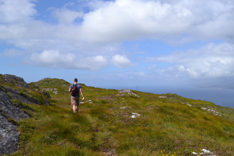
The Seefin loop walk leads you out along the ridge of the Sheep’s Head with spectacular views over Bantry Bay, Dunmanus Bay, and the ridge of the peninsula

The route climbs up to the ridge of the peninsula, and rewards you as you walk with views over Kilcrohane, our West Cork bays, the Mizen and Beara peninsulas and the West Cork islands in Bantry and Roaringwater bays.

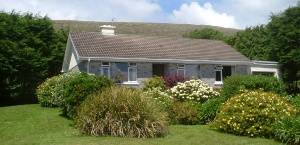
The chance to reward yourself with a fine feast, or a drink overlooking Kitchen Cove at Ahakista‘s Arundel’s By the Pier isn’t to be missed at the end of your journey.

seefin loop walk Sheep's Head peninsula

Seefin Loop Walk Details

From the car park at Arundel’s by the Pier, take a right onto the public road and continue on until you arrive at a tee junction (Ahakista Bridge).

Take a right here and then the first left as per the finger post sign and follow the blue arrows for Seefin. At the next finger post sign keep left and follow the blue arrows for Seefin in a northwesterly direction and at way marker no. 9 (Seefin) continue straight on along the track.

When you arrive at way marker no. 10 for Seefin take a left and follow the blue arrows in a southwesterly direction until you reach way marker no. 21 for Seefin. Take a right here and continue on in a northerly direction.

At The Windy Gap Junction sign (way marker no. 165) take the Seefin/Kilcrohane option keeping left in a southwesterly direction for the summit of Seefin. When you reach the top take a sharp left at the Trig Point/way marker no. 41.

Descend following the blue arrows and continue through to a farmyard. At way marker no. 64 you will go off road and then pass an old “Cillín” (little church or burial ground) and a fort on your way. At way marker no. 76 continue on down until you reach way marker no. 92 on the old Kilcrohane/Ahakista road. Take a left here and continue straight on along the old road.

You will eventually arrive onto a tarred road, passing by the Átha Thomáis memorial em route to the main public road. This will lead you back to Ahakista bridge and the car park at Arundel’s by the Pier.
 

Download GPX Files for GPS Devices:Download Seefin Loop Walk GPX file
Download File for 3D View in Google Earth:Download Seefin Loop Walk KMZ file
Start/Finish:Ahakista Trailhead: Arundels by the Pier car park.
Grade:Hard
Distance:12.1 km (approx)
Estimated Time:4hrs 15 mins (based on average walking speed of 3km per hour)
Arrows:Blue
Metres Climbed/ Ascent:475 metres
Maximum Height:345 metres
Dogs Allowed?No
Minimum Gear:Walking boots, rain gear, fluid, and a mobile phone.

Filed Under: Sheep's Head Way Loop Walks, Ahakista Trailhead, Hard, Walking

Mass Path Linear Walk (Ahakista to Dún Óir – Reversible)

February 3, 2014 by Dunmanus

The Mass Path Linear Walk leads you across the Sheep’s Head peninsula in West Cork with views over Bantry Bay and Dunmanus Bay

As this is a linear walk, you can walk it in either direction.

Ahakista to Dún Óir Direction

From the car park at Ahakista by Arundel’s By the Pier take a right onto the public road and continue on until you arrive at a T-junction (Ahakista Bridge). Take a right here and then the first left as per the finger post sign for Baran, Glanlough and Seefin.

At the next finger post sign, keep right for Glanlough and the Mass Path. Follow the purple arrows along the road for a while until you go off road and over a stile. At The Mass Path Junction sign/way marker no. 151, continue straight on taking the Dún Óir option.

From here on, follow the Christian Cross way marker symbols downhill until you reach the car park at Dún Óir.

You will go over a timber stile (way marker Christian Cross no. 1) before you enter the car park.
 

Dún Óir to Ahakista Direction

From the car park at Dún Óir go over the timber stile, way marker Christian Cross no. 1 and follow the Mass Path way markers uphill until you reach The Mass Path Junction sign/ way marker no. 151, take the Ahakista option (Straight on). Descend down off the hill and eventually you will reach a timber stile, Go over it and keep left, follow the road down until you reach a finger post sign. Keep left here and continue along the road until you reach the next finger post sign. Take a right here and this will lead you back to Ahakista bridge. At the bridge take a left for the car park at Arundels by the pier.

Note : Be aware of weather conditions and cut away peat bogs along the loop walk. Be aware of any livestock on the land, especially any Bulls. Please do not exit marked trails only on marked routes. No dogs are allowed on The Sheep’s Head Way.
 

Download GPX File for GPS:Download Mass Path Linear Walk GPX File
Download File for 3D View on Google Earth:Download Mass Path Linear Walk GPX File
Start: (Reversible)Ahakista Trailhead: Arundels by the Pier car park.
Finish:Dún Óir Trailhead at Dún Óir car park.
Grade:Hard
Distance:4.7 km (approx)
Estimated Time:1hr 45 mins (based on average walking speed of 3km per hour)
Arrows:Purple arrows and then the Mass Path signs (Christian cross symbol) from way marker no. 151 To the car park at Dún Óir.
Metres Climbed/ Ascent:224 metres
Maximum Height:205 metres
Dogs Allowed?No
Minimum Gear:Walking boots, rain gear, fluid, and a mobile phone.
Facilities:This walk is nearest to the village of Ahakista

Filed Under: Ahakista Trailhead, Dún Óir Trailhead, Walking

Barán Loop Walk

February 3, 2014 by Dunmanus


The Barán Loop on the Sheep’s Head peninsula forms part of the Sheep’s Head Way walking route on the Sheep’s Head peninsula

From the car park at Arundel’s by the Pier in Ahakista follow the signs for the Barán Loop Walk. Take a right onto the public road and continue on until you arrive at a T-junction (Ahakista Bridge). Take a right here and then the first left as per the finger post sign and follow the green arrows for Barán.

At the next finger post sign for the Barán Loop Walk, keep left and follow the green arrows for Barán in a northwesterly direction. At way marker no. 9 (Barán), continue straight on along the track. When you arrive at way marker no. 10 for Barán, take a left and follow the green arrows in a southwesterly direction until you reach way marker no. 21 for Barán.

At no. 21, take a left and continue on down in a southeasterly direction until you reach way marker no. 440 on the old Kilcrohane/Ahakista road. Take a left here and continue straight on along the old road and you will eventually arrive onto a tarred road, passing by the Átha Thomáis memorial en route to the main public road. This will lead you back to Ahakista bridge and the car park at Arundel’s by the Pier.
 

Download GPX File for GPS:Download Barán Loop Walk GPX File
Download File for 3D View in Google Earth:Download Barán Loop Walk KMZ File
Start/Finish:Ahakista Trailhead: Arundels by the Pier car park.
Grade:Hard
Distance:7.9 km (approx)
EstimaTed time:2 hours and 45mins (based on average walking speed of 3km per hour)
Arrows:Green
Metres Climbed/ Ascent:323 metres
Maximum Height:310 metres
Dogs Allowed?No
Minimum Gear:Walking boots, rain gear, fluid, and a mobile phone.

Filed Under: Ahakista Trailhead, Ahakista, Level: Hard, Sheep's Head Way Loop Walks, Walking

Glanlough Loop Walk | Sheep’s Head Way

February 3, 2014 by Dunmanus

The Glanlough Loop Walk

The Glanlough Loop walk on the Sheep’s Head Way follows minor roadways, lanes and mountain paths as it leads you up along the ridge that forms the spine of the Sheep’s Head peninsula. It then moves down, past the lovely Glanlough Lake on a route that showcases stunning mountain, coastal and sea views across Bantry Bay, Dunmanus Bay, and the neighbouring Mizen and Beara peninsulas.

From the car park at Ahakista take a right onto the public road and continue on until you arrive at a T-junction (Ahakista Bridge). Take a right here and then the first left as per the finger post sign for Glanlough. At the next finger post sign keep right for Glanlough and the Mass Path.

Follow the purple arrows along the road for a while until you go off-road and over a stile. At The Mass Path Junction sign/way marker no. 151, take the Sheep’s Head Way East Glanlough/Bantry option and continue along the ridge.

At way marker 111 you will begin to descend in a north-easterly direction until you reach way marker no. 91 at the road.

Keep right and continue along the road. At way marker no. 90 keep left, and at way marker no. 89 turn right, continue on up the road following the purple arrows passing the car park at Glanlough. At the finger post sign for “Durrus” turn left and stay along the road until you reach way marker no. 512.

At this point you turn right off road and onto a track and continue along in a southwesterly direction. At way marker no. 498, you will veer right and continue on until you join the road again at way marker no. 490. Follow the purple arrows again along the road and at way marker no. 487 turn right up another road. Continue along the road and at way marker no. 483 turn left off the road in a westerly direction.

When you reach way marker no. 462, turn left onto the road which leads you back to the T-junction, take a right here and this will lead you back to Ahakista bridge, and at the bridge take a left for the car park at Arundels by the Pier.

Note: Be aware of weather conditions and cut away peat bogs along the loop walk. Be aware of any livestock on the land, especially any bulls. Please do not exit marked trails. Walk only on marked routes. No dogs are allowed on The Sheep’s Head Way.
 

Download GPX File for GPS:Download Glanlough Loop Walk GPX file
Download 3D Route Map for Google Earth:Download Glanlough Loop Walk KMZ file
Start/Finish:Ahakista Trailhead: Arundels by the Pier car park.
Grade:Hard
Distance:14.9 km (approx)
Estimated time:5 hours (based on speed of 3km per hour)
Metres Climbed/ Ascent:510 metres
Maximum Height:270 metres
Dogs Allowed?No
Minimum Gear:Walking boots, rain gear, fluid, and a mobile phone.

Filed Under: Ahakista, Ahakista Trailhead, Estimated Time: 5 hours or more, Hard, Sheep's Head Way Loop Walks, Walking

Wild Atlantic Way

What’s On

No event found!

Visit Historic Places

Bantry House B&B

The Sheep’s Head is a peninsula rich in history and you’ll find traces of its past all along the Sheep’s Head Way walking route.

Find out more

Pure cork

Featured Activity

Stone-Cutting Courses

Stone-Carving Courses

Learn traditional stonework skills in stone carving courses under the tuition of an experienced stonecarver on West Cork’s Sheep’s Head peninsula. Victor Daly leads regular letter-cutting and stone carving courses at his workshop just outside the village of Ahakista on the Sheep’s Head peninsula in West Cork. His 2-day stone-carving workshops are held throughout the […]

More Activities

Featured Accommodation

Tíg na Fáilte Holiday home

Tíg na Fáilte Holiday Home

Tíg na Fáilte is a comfortable and welcoming holiday home on West Cork’s stunning Sheep’s Head peninsula. This lovely Irish holiday home on West Cork’s Sheep’s Head peninsula offers wonderful views of Dunmanus Bay from the living room, kitchen and all three bedrooms. The master bedroom with double bed and en-suite, is on the first […]

More Accommodation

This project has been supported by Cork County Council & the LEADER programme under the Rural Development Programmes 2007-13 and 2017-2021.
  • The Sheep’s Head Way
  • Loop Walks
  • Accommodation
Sheep's Head & Bantry Tourism Cooperative, copyright 2018 | Website by Wordhoard Communications