Living the Sheep's Head Way

  • The Sheep’s Head Way
  • Loop Walks
  • Accommodation
    • B&Bs
    • Hotels
    • Farmhouse Accommodation
    • Campsites

MENUMENU
  • Home
  • Things to Do
    • Walking
      • Sheep's Head Way Main Route
      • Loop Walks
        • Difficulty
          • Easy
          • Moderate
          • Hard
        • Time
          • Under 3 hours
          • 3-5 hours
          • 5 hours or more
        • Trailheads
          • Ahakista
          • Bantry West
          • Black Gate
          • Dún Óir
          • Durrus
          • Goat's Path
          • Kilcrohane
          • Tooreen
          • Whiddy Island
      • Walking Guides
    • Courses & Training
    • Crafts
    • Culture
    • Gardens
    • History
    • Cycling
    • Pony Trekking
    • Sailing & Kayaking
  • What's On
    • Events
    • Scheduled Courses
    • Festivals
  • Food
    • Cafés
    • Restaurants
    • Food Producers
    • Food Tours
    • Coeliac-Friendly
  • Where to Stay
    • B&B
    • Hotels
    • Self-Catering Holiday Homes
    • Farmhouse Accommodation
    • Campsites
    • Luxury Accommodation
    • Accessible Accommodation
  • News
  • How to Get Here
  • Location
    • Map
    • Ahakista
    • Bantry
    • Ballylickey
    • Drimoleague
    • Durrus
    • Kilcrohane
    • Whiddy Island
  • Services
    • Shops
    • Taxi Services
  • Contact Us
You are here: Home / Archives for Hard

Mount Corrin Loop Walk | Sheep’s Head Way

August 21, 2014 by Dunmanus

Mount Corrin Loop Walk c PeterClarke

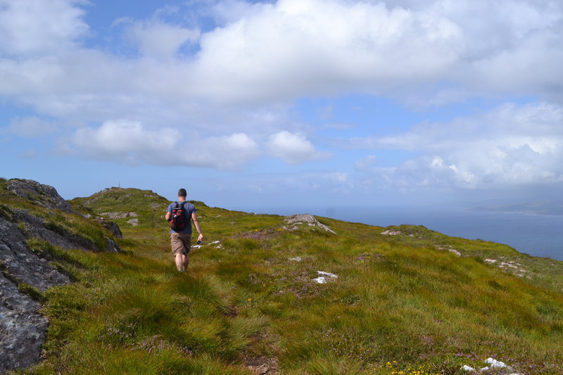
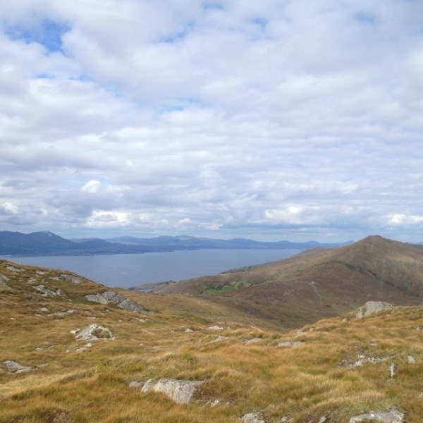
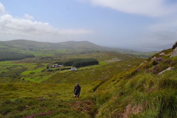
The Mount Corrin Loop Walk is a six-hour hike on the Sheep’s Head Way that rewards you with gorgeous views over West Cork’s hills and Dunmanus Bay

It’s dotted with sights of historic interest too, from cairns to megalithic tombs. Well worth the effort!

“The views from the cairn are stupendous, taking in the West Cork peninsulas and the hinterland across to the Kerry mountains.” (Roaringwater Journal)

Mount Corrin Loop Walk Sheep's Head Way near Durrus

Mount Corrin Loop Walk Route

To begin the Mount Corrin Loop Walk on West Cork’s Sheep’s Head peninsula, set out from Durrus village along the old creamery road passing Wiseman’s hardware store on your way.

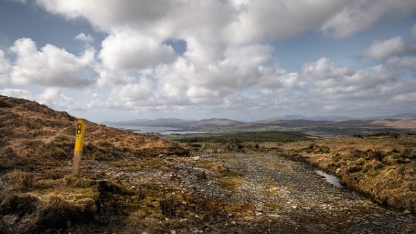
The well-signposted walk is part of the Sheep’s Head Way hiking route on Ireland’s southwest coastline.

Continue on along the road for a good while until you reach way marker no. 570 on a telephone pole, take a right here and go up another road. At way marker no. 572 you will go off road and through farm land and tracks until you will arrive at a timber stile, way marker no. 600 and a gate with an information sign on it. Go right after going over the timber stile and continue along the road until you reach another timber stile, way marker no. 603. Go left over the timber stile and onto the land, continue on up until you reach way marker no. 619 and take the Mount Corrin option which is straight on ahead and over a timber stile.

Continue on up along. Further on down, you will reach an information sign beside the road and take the Mount Corrin/Dunbeacon option. Across the road you will see way marker no. 397 and from here you will set out for Mount Corrin. On reaching the summit you will descend down onto the Mine Road via a timber stile way marker no. 975. (There is an information sign here also at this point, so you can opt for going back to Durrus village or the car park at Dunbeacon Church).

Take a right here along the road and continue on until way marker no. 976 on a telephone pole, if you want to go to the car park at Dunbeacon Church turn left here and the road will lead you there.

Continue down the Mines Road. (To the left is a marked path to the Dunbeacon Stone Circle if you wish to visit it, adding about 1km to the route. A short distance further on, to the left, is a short path to the Coolcoulaghta Stone Row).

Just before the Mines Road meets the R591 road to Durrus, look out for a stile on the left. This will take you across fields and a boreen to another small road where you turn right. Follow this road to the T-junction where you turn left and then left again at the next junction before turning right onto the R591 road which will lead you back to Durrus village from where you started.

Note : Be aware of weather conditions and cut away peat bogs along the loop walk. Be aware of any livestock on the land, especially any bulls. Please do not exit marked trails. Stay on marked routes, and remember that no dogs are allowed on the Sheep’s Head Way.

The Mount Corrin Loop Walk is one of 20 colour-coded Sheep’s Head Way loop walks.

Plan your visit here at https://livingthesheepsheadway.com

Download GPX FileDownload Mount Corrin Loop Walk GPX file
View Route in 3D on Google Earth:Download Mount Corrin Loop Walk KMZ file
Start/Finish:Durrus Trailhead or Dunbeacon Church car park.
Grade:Hard
Arrows:Follow the purple arrows & yellow 'walking man' markers
Distance:17.1 km (approx)
Estimated time:6 hours (based on average walking speed of 3 km per hour)
Metres Climbed/ Ascent:585 metres
Maximum Height:301 metres
Dogs Allowed?No
Minimum Gear:Walking boots, rain gear, fluid, and a mobile phone.

Filed Under: Durrus, Durrus Trailhead, Estimated Time: 5 hours or more, Hard, Level: Hard, Sheep's Head Way Loop Walks

Seefin Loop Walk

April 3, 2014 by Dunmanus

The Seefin loop walk leads you out along the ridge of the Sheep’s Head with spectacular views over Bantry Bay, Dunmanus Bay, and the ridge of the peninsula

The route climbs up to the ridge of the peninsula, and rewards you as you walk with views over Kilcrohane, our West Cork bays, the Mizen and Beara peninsulas and the West Cork islands in Bantry and Roaringwater bays.

The chance to reward yourself with a fine feast, or a drink overlooking Kitchen Cove at Ahakista‘s Arundel’s By the Pier isn’t to be missed at the end of your journey.

seefin loop walk Sheep's Head peninsula

Seefin Loop Walk Details

From the car park at Arundel’s by the Pier, take a right onto the public road and continue on until you arrive at a tee junction (Ahakista Bridge).

Take a right here and then the first left as per the finger post sign and follow the blue arrows for Seefin. At the next finger post sign keep left and follow the blue arrows for Seefin in a northwesterly direction and at way marker no. 9 (Seefin) continue straight on along the track.

When you arrive at way marker no. 10 for Seefin take a left and follow the blue arrows in a southwesterly direction until you reach way marker no. 21 for Seefin. Take a right here and continue on in a northerly direction.

At The Windy Gap Junction sign (way marker no. 165) take the Seefin/Kilcrohane option keeping left in a southwesterly direction for the summit of Seefin. When you reach the top take a sharp left at the Trig Point/way marker no. 41.

Descend following the blue arrows and continue through to a farmyard. At way marker no. 64 you will go off road and then pass an old “Cillín” (little church or burial ground) and a fort on your way. At way marker no. 76 continue on down until you reach way marker no. 92 on the old Kilcrohane/Ahakista road. Take a left here and continue straight on along the old road.

You will eventually arrive onto a tarred road, passing by the Átha Thomáis memorial em route to the main public road. This will lead you back to Ahakista bridge and the car park at Arundel’s by the Pier.
 

Download GPX Files for GPS Devices:Download Seefin Loop Walk GPX file
Download File for 3D View in Google Earth:Download Seefin Loop Walk KMZ file
Start/Finish:Ahakista Trailhead: Arundels by the Pier car park.
Grade:Hard
Distance:12.1 km (approx)
Estimated Time:4hrs 15 mins (based on average walking speed of 3km per hour)
Arrows:Blue
Metres Climbed/ Ascent:475 metres
Maximum Height:345 metres
Dogs Allowed?No
Minimum Gear:Walking boots, rain gear, fluid, and a mobile phone.

Filed Under: Sheep's Head Way Loop Walks, Ahakista Trailhead, Hard, Walking

Gortnakilly Loop Walk | Sheep’s Head Way

February 5, 2014 by Dunmanus

Take the Gortnakilly Loop Walk on the north side of the award-winning Sheep’s Head peninsula and enjoy stunning views across Bantry Bay

From the car park at Dún Óir on the north side of the peninsula, go over the timber stile way marker, Christian Cross no. 1. Follow the Mass Path way markers uphill until you reach The Mass Path Junction sign/ way marker no. 151.

Take the Sheep’s Head Way West Barán/Seefin option. Continue on until you reach The Windy Gap Junction sign/way marker no. 165 and take the Sheep’s Head Way West via the Goat’s Path option. Continue on down until you reach way marker no. 178.

At this point you will be walking down in a generally northerly direction until you meet the public road at way marker no. 190. Take a right turn here, and continue along the public road in a northeasterly direction and back to the car park at Dún Óir.
 

Download GPX file for GPS devices:File for Gortnakilly Loop Walk route
Start/Finish:Dún Óir Trailhead
Grade:Hard
Distance:7.9 km (approx)
Estimated time:2 hrs 45 mins (based on average walking speed of 3 km per hour)
Arrows:Orange arrows and follow the Mass Path Way markers (Christian Cross Symbol) until way marker no. 151. Then follow the main Sheep's Head Way yellow man markers.
Metres Climbed/ Ascent:302 metres
Maximum Height:270 metres
Dogs Allowed?No
Minimum Gear:Walking boots, rain gear, fluid, and a mobile phone.
Download file for 3D View on Google Earth:KMZ file for Gortnakilly Loop Walk route

Filed Under: Dún Óir Trailhead, Estimated Time: Under 3 hours, Hard, Sheep's Head Way Loop Walks, Walking

Cahergal Loop Walk

February 3, 2014 by Dunmanus

The Cahergal Loop Walk on the Sheep’s Head peninsula introduces you to the beauty and peace of an area recognised as a European Destination of Excellence

From the car park at the Black Gate and Alice West Centre past the village of Kilcrohane, follow the purple loop walk arrows for the Cahergal Loop Walk in a northeasterly direction along the public road for a short distance.

At way marker no. 3 (Peakeen, Cahergal and Caher), turn left off the public road. Continue up the track and onto the hill going through 4 stiles en-route until you reach way marker no. 15 (Peakeen and Cahir) and turn left.

Continue on, crossing the peninsula to the Bantry Bay side, until you reach the car park at Cahergal. Keep left after going over the timber stile and cross the road where you will go over another timber stile, passing way marker no. 206.

Continue straight on for the cove, passing the the ruins of a famine hamlet known locally as the “Crimea” and the abandoned copper mines, en route. At way marker no. 238, keep left and walk a short distance along the pubic road. Turn right at the finger post sign for “The Poet’s Way” and go off-road over a timber stile, at way marker no. 65 Poet’s Way/Cahergal. Follow the way markers to traverse the peninsula to the south side until you meet way marker no. 348.

Turn left here and continue straight on until way marker no. 354 and turn right. Continue on down to the public road and back to the Black Gate / Alice West Centre.
 

Download GPX file for GPS:Download Cahergal Loop Walk GPX file
Download file for 3D View on Google Earth:Download Cahergal Loop Walk KMZ file
Start/Finish:Black Gate Trailhead
Grade:Hard
Distance:8.4 km (approx)
Estimated Time:3 hrs (based on average walking speed of 3 km per hour)
Arrows:Purple
Metres Climbed/ Ascent:371 metres
Maximum Height:184 metres
Dogs Allowed?No
Minimum Gear:Walking boots, rain gear, fluid, and a mobile phone.

Filed Under: Black Gate trailhead, Estimated Time: Under 3 hours, Hard, Kilcrohane, Sheep's Head Way Loop Walks, Walking

Caher Loop Walk | Sheep’s Head Way

February 3, 2014 by Dunmanus

The Caher Loop Walk leads you up to the ridge of the Sheep’s Head peninsula, with fine views over Bantry Bay and Dunmanus Bay!

From the car park at the Black Gate / Alice West Centre just outside Kilcrohane village, follow the green loop walk arrows in a northeasterly direction along the public road for a short distance.

At way marker no. 3 (Peakeen, Cahergal and Cahir) turn left off the public road. Continue up the track and onto the hill going through 4 stiles en route until you reach way marker no. 17 marked Peakeen/Cahir.

Turn right down the hill beyond Cahir lake on an old road. When this road meets the public road turn left. Walk along the public road for a short distance then turning right downhill again onto “the stony roadeen” passing by a private garden.

Next veer right onto the public road again for a considerable distance. At way marker no. 368, veer right again walking in a southwesterly direction on the public road passing “The Cill” at Caher, a famine graveyard en route. The loop enters farmland at way marker no. 366 and descends towards the sea.

At Trá Rúaim strand, veer right uphill on the public by-road and right again when this road meets the main public road to return to The Black Gate.
 

Download GPX file for GPS:Download Caher Loop Walk GPX file
Download File for 3D View on Google Earth:Download Caher Loop Walk KMZ file
Start/Finish:Black Gate Trailhead
Grade:Hard
Distance:5.6 km (approx)
Estimated Time:2 hrs (based on average walking speed of 3 km per hour)
Arrows:Green Arrows
Metres Climbed/ Ascent:210 metres
Maximum Height:189 metres
Dogs Allowed?No
Minimum Gear:Walking boots, rain gear, fluid, and a mobile phone.

Filed Under: Black Gate trailhead, Estimated Time: Under 3 hours, Hard, Sheep's Head Way Loop Walks, Walking

Peakeen Ridge Loop Walk | Sheep’s Head Way

February 3, 2014 by Dunmanus

The Peakeen Ridge Loop Walk begins above Kilcrohane on West Cork’s Sheep’s Head peninsula

It’s a gorgeous walk out along the ridge of the Sheep’s Head. At every time of year, you’ll find something to delight the eye as you look across bays, moorland and lush green valleys. The walk is a perfect introduction to Ireland’s Wild Atlantic Way walks!

Look out for a passage tomb and a Mass Rock along your route. Why not call down to the village of Kilcrohane after your walk for dinner at The Old Creamery, or a visit to the Sheep’s Head Producer’s Shop?

Peakeen Ridge Loop Walk Sheep's Head Way

Peeakeen Ridge Loop Walk Details

Begin your walk behind the Pietà statue, and follow a route that leads you along the ridge of the Sheep’s Head peninsula, with spectacular views out over Dunmmanus Bay, the Mizen peninsula, and the Fastnet Rock to the east. To the west, you’ll see Bantry Bay, Beara, Bere Island, and even the Bull Rock on a clear day.

From the car park at the top of the Goat’s Path, follow the orange arrows and orange ‘walking man’ way markers heading in a southwesterly direction, passing behind the Pietà statue and marker no. 60 (Peakeen) as you go.

Continue on along the ridge passing a megalithic tomb en route. Further on you will descend the hill and almost straight away you will ascend another hill. Continue on along the ridge again until you will start to descend again at way marker no. 15 (Peakeen, Caher) veer right following the way markers for Cahergal.

As you go over the stile at the public road at Cahergal car park, keep right at way marker no. 205 and continue along the public road in a northeasterly direction. At the finger post sign for “Horse-shoe Road” and Finn McCool’s Seat near way marker 200.

Turn right here, and this track will take you back to the public road to way marker no. 194. Turn right here and the road takes you back to the car park at the top of The Goat’s Path.
 

Download GPX File for GPS:Download Peakeen Ridge Loop Walk GPX file
Download File for 3D View on Google Earth:Download Peakeen Ridge Loop Walk KMZ file
Start/Finish:Goat's Path trailhead.
Grade:Hard
Distance:11 km (approx)
Estimated Time:3 hrs 45 mins (based on average walking speed of 3 km per hour)
Arrows:Cream and red arrows
Metres Climbed/ Ascent:470 metres
Maximum Height:338 metres
Dogs Allowed?No
Minimum Gear:Walking boots, rain gear, fluid, and a mobile phone.
Facilities:Car Parking spaces available and bike rack.
Nearest village: Kilcrohane

Filed Under: Goat's Path Trailhead, Estimated Time: 3-5 hours, Hard, Kilcrohane, Sheep's Head Way Loop Walks, Walking

  • 1
  • 2
  • Next Page »
Wild Atlantic Way

What’s On

No event found!

Visit Historic Places

Bantry House B&B

The Sheep’s Head is a peninsula rich in history and you’ll find traces of its past all along the Sheep’s Head Way walking route.

Find out more

Pure cork

Featured Activity

Glenilen Farm

Glenilen Farm

When Valerie Kingston began bringing cheesecakes to sell at Bantry market in 1997, she found that people just loved the rich tasty milk produced on Glenilen farm in Drimoleague. Today, Alan and Valerie’s cheesecakes, yoghurts and desserts have gained a reputation across Ireland and beyond, and the family farm is a hive of activity. But […]

More Activities

Featured Accommodation

Westlodge Hotel

Westlodge Hotel

The Westlodge Hotel & Estate situated on the edge of the beautiful town of Bantry in the heart of West Cork, sits on an elevated site overlooking Bantry Bay. The hotel is set within 25 acres of landscaped gardens with nature trails & the pond that is home to ducks and many wildlife species. With […]

More Accommodation

This project has been supported by Cork County Council & the LEADER programme under the Rural Development Programmes 2007-13 and 2017-2021.
  • The Sheep’s Head Way
  • Loop Walks
  • Accommodation
Sheep's Head & Bantry Tourism Cooperative, copyright 2018 | Website by Wordhoard Communications