Living the Sheep's Head Way

  • The Sheep’s Head Way
  • Loop Walks
  • Accommodation
    • B&Bs
    • Hotels
    • Farmhouse Accommodation
    • Campsites

MENUMENU
  • Home
  • Things to Do
    • Walking
      • Sheep's Head Way Main Route
      • Loop Walks
        • Difficulty
          • Easy
          • Moderate
          • Hard
        • Time
          • Under 3 hours
          • 3-5 hours
          • 5 hours or more
        • Trailheads
          • Ahakista
          • Bantry West
          • Black Gate
          • Dún Óir
          • Durrus
          • Goat's Path
          • Kilcrohane
          • Tooreen
          • Whiddy Island
      • Walking Guides
    • Courses & Training
    • Crafts
    • Culture
    • Gardens
    • History
    • Cycling
    • Pony Trekking
    • Sailing & Kayaking
  • What's On
    • Events
    • Scheduled Courses
    • Festivals
  • Food
    • Cafés
    • Restaurants
    • Food Producers
    • Food Tours
    • Coeliac-Friendly
  • Where to Stay
    • B&B
    • Hotels
    • Self-Catering Holiday Homes
    • Farmhouse Accommodation
    • Campsites
    • Luxury Accommodation
    • Accessible Accommodation
  • News
  • How to Get Here
  • Location
    • Map
    • Ahakista
    • Bantry
    • Ballylickey
    • Drimoleague
    • Durrus
    • Kilcrohane
    • Whiddy Island
  • Services
    • Shops
    • Taxi Services
  • Contact Us
You are here: Home / Archives for Hard

Glanlough Loop Walk | Sheep’s Head Way

February 3, 2014 by Dunmanus

The Glanlough Loop Walk

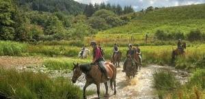
The Glanlough Loop walk on the Sheep’s Head Way follows minor roadways, lanes and mountain paths as it leads you up along the ridge that forms the spine of the Sheep’s Head peninsula. It then moves down, past the lovely Glanlough Lake on a route that showcases stunning mountain, coastal and sea views across Bantry Bay, Dunmanus Bay, and the neighbouring Mizen and Beara peninsulas.

From the car park at Ahakista take a right onto the public road and continue on until you arrive at a T-junction (Ahakista Bridge). Take a right here and then the first left as per the finger post sign for Glanlough. At the next finger post sign keep right for Glanlough and the Mass Path.

Follow the purple arrows along the road for a while until you go off-road and over a stile. At The Mass Path Junction sign/way marker no. 151, take the Sheep’s Head Way East Glanlough/Bantry option and continue along the ridge.

At way marker 111 you will begin to descend in a north-easterly direction until you reach way marker no. 91 at the road.

Keep right and continue along the road. At way marker no. 90 keep left, and at way marker no. 89 turn right, continue on up the road following the purple arrows passing the car park at Glanlough. At the finger post sign for “Durrus” turn left and stay along the road until you reach way marker no. 512.

At this point you turn right off road and onto a track and continue along in a southwesterly direction. At way marker no. 498, you will veer right and continue on until you join the road again at way marker no. 490. Follow the purple arrows again along the road and at way marker no. 487 turn right up another road. Continue along the road and at way marker no. 483 turn left off the road in a westerly direction.

When you reach way marker no. 462, turn left onto the road which leads you back to the T-junction, take a right here and this will lead you back to Ahakista bridge, and at the bridge take a left for the car park at Arundels by the Pier.

Note: Be aware of weather conditions and cut away peat bogs along the loop walk. Be aware of any livestock on the land, especially any bulls. Please do not exit marked trails. Walk only on marked routes. No dogs are allowed on The Sheep’s Head Way.
 

Download GPX File for GPS:Download Glanlough Loop Walk GPX file
Download 3D Route Map for Google Earth:Download Glanlough Loop Walk KMZ file
Start/Finish:Ahakista Trailhead: Arundels by the Pier car park.
Grade:Hard
Distance:14.9 km (approx)
Estimated time:5 hours (based on speed of 3km per hour)
Metres Climbed/ Ascent:510 metres
Maximum Height:270 metres
Dogs Allowed?No
Minimum Gear:Walking boots, rain gear, fluid, and a mobile phone.

Filed Under: Ahakista, Ahakista Trailhead, Estimated Time: 5 hours or more, Hard, Sheep's Head Way Loop Walks, Walking

Poet’s Way Loop Walk | Sheep’s Head Way

January 15, 2014 by Dunmanus

The Poet’s Way Loop Walk on the Sheep’s Head Way is named for the poet Denis M. Cronin who was born in the townland of Eskeraha on the peninsula

His epic poem ‘The Chase of a Shadow’ was written in 1898 and salutes the beauty of this part of the world:

From pole to pole should my migration bend;
Or twice around the world should they extend,
No place in all those travels could be found,
To my mind’s eye, so adequately crowned
With nature’s diadems, serene, profuse,
At these romantic and unrivaled views.

The nearly 200-page narrative poem tells the story of Fergus, a young Irish aristocrat from The Sheep’s Head peninsula who is separated from his family, his country and his true love by Ireland’s 1798 rebellion.

For the modern hiker on the Poet’s Way Loop Walk, this loop walk takes you past dazzling inlets, coves, blow holes and sea arches along the way. You’ll also see a ruined 17th-century signal tower as you go, and the summit of Ballyroon Mountain provides spectacular views over Bantry Bay, Dunmanus Bay, and the Mizen and Beara peninsulas.

Poet’s Way Loop Walk Route

From the car park at Tooreen follow the red loop walk arrows. Set out in a southwesterly direction on the Dunmanus Bay side of the peninsula to the lighthouse passing Lough Akeen en route.

After the helicopter pad, the Sheep’s Head lighthouse comes into view and if you wish you can climb the concrete steps that lead up to it!

The loop returns on the Bantry Bay side, and at the Daingean sign near way marker no. 272 continue straight along the main route. At way marker no. 238 veer right and walk a short distance along the public road. Turn right at the finger post sign for “The Poet’s Way” and go off road over a timber stile, way marker no. 65 Poet’s Way/Cahergal.

Follow the way markers to traverse the peninsula to the south side until you meet way marker no. 348. At this way marker turn right and continue on along in a southwesterly direction. You will then descend downhill and go over a timber stile and onto the road.

Turn left here along the road for a short distance passing the “Fáilte Faill Bheag” sign on your way. At way marker no. 337 turn right up a tarred road and onto a track. Continue on passing the ruins of an old signal tower and a World War Two look out post further on, until you will descend and return back to the car park at Tooreen.
 
Note: Be aware of weather conditions, unprotected dangerous cliffs and cut away peat bogs along the loop walk. Be aware of any livestock on the land, especially any bulls. Please do not exit marked trails only on marked routes. No dogs are allowed on The Sheep’s Head Way.

Emergency: Phone 999 or 112 and state whether you need Ambulance, Gardaí (police), Fire Brigade or Mountain Rescue.

To identify your location on the Poet’s Way Loop walk, please quote the number of the nearest way marker pole or your GPS/grid co-ordinates.

LEAVE NO TRACE

• plan ahead and prepare
• be considerate of others
• respect farm animals and wildlife
• leave what you find
• camp on approved sites or with landowner’s permission
• dispose of waste properly

Practising a Leave No Trace ethic is very simple: make it hard for others to see or hear you and leave no trace of your visit.
 

Download GPX File for GPS:Download Poet's Way Loop Walk GPX file
Download File for 3D View on Google Earth:Download Poet's Way Loop Walk KMZ file
Start/End Point:Car park at the end of the road on the Sheep's Head peninsula.
Length:12.4 kilometres
Difficulty:Difficult
Estimated Time:4 hours 30 minutes (Based on average walking speed of 3km per hour)
Arrows:Red
Terrain:Paths, tracks, rocky trails, minor roads.
Ascent:462 metres
Max Height:239 metres
Facilities:The walk begins and ends near the Cupán Tae cafe. Car park, bike rack, and public toilet available.

Filed Under: Estimated Time: 3-5 hours, Hard, Sheep's Head Way Loop Walks, Tooreen Trailhead, Walking

  • « Previous Page
  • 1
  • 2
Wild Atlantic Way

What’s On

No event found!

Visit Historic Places

Bantry House B&B

The Sheep’s Head is a peninsula rich in history and you’ll find traces of its past all along the Sheep’s Head Way walking route.

Find out more

Pure cork

Featured Activity

Stone-Cutting Courses

Stone-Carving Courses

Learn traditional stonework skills in stone carving courses under the tuition of an experienced stonecarver on West Cork’s Sheep’s Head peninsula. Victor Daly leads regular letter-cutting and stone carving courses at his workshop just outside the village of Ahakista on the Sheep’s Head peninsula in West Cork. His 2-day stone-carving workshops are held throughout the […]

More Activities

Featured Accommodation

Bantry House B&B Accommodation

Bed and breakfast at Bantry House B&B and you’ll enjoy a truly wonderful experience on your West Cork holiday Choose one of the elegantly-restored rooms in the East Wing, overlooking the famous Hundred Steps and Parterre. You’ll enjoy a full Irish breakfast and continental buffet, and Ann’s scone recipe here is much-coveted! As a guest […]

More Accommodation

This project has been supported by Cork County Council & the LEADER programme under the Rural Development Programmes 2007-13 and 2017-2021.
  • The Sheep’s Head Way
  • Loop Walks
  • Accommodation
Sheep's Head & Bantry Tourism Cooperative, copyright 2018 | Website by Wordhoard Communications