Living the Sheep's Head Way

  • The Sheep’s Head Way
  • Loop Walks
  • Accommodation
    • B&Bs
    • Hotels
    • Farmhouse Accommodation
    • Campsites

MENUMENU
  • Home
  • Things to Do
    • Walking
      • Sheep's Head Way Main Route
      • Loop Walks
        • Difficulty
          • Easy
          • Moderate
          • Hard
        • Time
          • Under 3 hours
          • 3-5 hours
          • 5 hours or more
        • Trailheads
          • Ahakista
          • Bantry West
          • Black Gate
          • Dún Óir
          • Durrus
          • Goat's Path
          • Kilcrohane
          • Tooreen
          • Whiddy Island
      • Walking Guides
    • Courses & Training
    • Crafts
    • Culture
    • Gardens
    • History
    • Cycling
    • Pony Trekking
    • Sailing & Kayaking
  • What's On
    • Events
    • Scheduled Courses
    • Festivals
  • Food
    • Cafés
    • Restaurants
    • Food Producers
    • Food Tours
    • Coeliac-Friendly
  • Where to Stay
    • B&B
    • Hotels
    • Self-Catering Holiday Homes
    • Farmhouse Accommodation
    • Campsites
    • Luxury Accommodation
    • Accessible Accommodation
  • News
  • How to Get Here
  • Location
    • Map
    • Ahakista
    • Bantry
    • Ballylickey
    • Drimoleague
    • Durrus
    • Kilcrohane
    • Whiddy Island
  • Services
    • Shops
    • Taxi Services
  • Contact Us
You are here: Home / Archives for Walking

Farranamanagh Loop Walk | Sheep’s Head Way

February 3, 2014 by Dunmanus

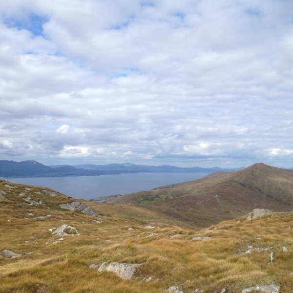
The Farranamanagh loop walk is a coastal trail that leads you from Kilcrohane village out along the edge of the Sheep’s Head peninsula

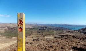
From The Old Creamery in Kilcrohane, walk in a northeasterly direction back up the peninsula following the red arrows and main Sheep’s Head Way ‘yellow man’ markers.

At marker no. 404, turn right off the main public road entering farmland. Continue on downhill to Farranamanagh strand and lake, walking beyond these and on uphill on rough ground beyond the Bardic School.

Farranamanagh loop walkThe school was home to O Dalys – chief poets to the O Mahony clan – and it was here on the coast of the Sheep’s Head peninsula that they passed the Irish poetic tradition from generation to generation.

Continue on to meet the main public road, turn left and you will arrive at Dromnea car park, way marker no. 425.

Here you can return directly to Kilcrohane village via the public road or continue on the loop by climbing the old stone stile to the left of the gate across the road.

Continue on uphill until you reach way marker no. 92 on the old Kilcrohane/Ahakista road. Continue straight on again until you reach way marker no. 01, veer left here for Kilcrohane, and continue on again in a southwesterly direction.

At way marker no. 10 follow the road down until you meet the main road. Take a right turn here and the main road will lead you back to Kilcrohane village, where a bite to eat at The Old Creamery will be a welcome reward for your walk!

The Farranamanagh Loop Walk is one of 20 loop walks along the Sheep’s Head Way Walking route on Ireland’s southwest coastline.


Download GPX file for GPSGPX file for Farranamanagh loop walk
Download to View in 3D on Google Maps:KMZ file for Farranamanagh loop walk
Start/Finish:Kilcrohane trailhead.
Grade:Moderate
Distance:6.1 km (approx)
Estimated time:2 hrs 15 mins (based on average walking speed of 3 km per hour)
Arrows:Red
Metres Climbed/ Ascent:236 metres
Maximum Height:110 metres
Dogs Allowed?No
Minimum Gear:Walking boots, rain gear, fluid, and a mobile phone.

Filed Under: Estimated Time: Under 3 hours, Kilcrohane, Kilcrohane Trailhead, Moderate, Sheep's Head Way Loop Walks, Walking

Peakeen Ridge Loop Walk | Sheep’s Head Way

February 3, 2014 by Dunmanus

The Peakeen Ridge Loop Walk begins above Kilcrohane on West Cork’s Sheep’s Head peninsula

It’s a gorgeous walk out along the ridge of the Sheep’s Head. At every time of year, you’ll find something to delight the eye as you look across bays, moorland and lush green valleys. The walk is a perfect introduction to Ireland’s Wild Atlantic Way walks!

Look out for a passage tomb and a Mass Rock along your route. Why not call down to the village of Kilcrohane after your walk for dinner at The Old Creamery, or a visit to the Sheep’s Head Producer’s Shop?

Peakeen Ridge Loop Walk Sheep's Head Way

Peeakeen Ridge Loop Walk Details

Begin your walk behind the Pietà statue, and follow a route that leads you along the ridge of the Sheep’s Head peninsula, with spectacular views out over Dunmmanus Bay, the Mizen peninsula, and the Fastnet Rock to the east. To the west, you’ll see Bantry Bay, Beara, Bere Island, and even the Bull Rock on a clear day.

From the car park at the top of the Goat’s Path, follow the orange arrows and orange ‘walking man’ way markers heading in a southwesterly direction, passing behind the Pietà statue and marker no. 60 (Peakeen) as you go.

Continue on along the ridge passing a megalithic tomb en route. Further on you will descend the hill and almost straight away you will ascend another hill. Continue on along the ridge again until you will start to descend again at way marker no. 15 (Peakeen, Caher) veer right following the way markers for Cahergal.

As you go over the stile at the public road at Cahergal car park, keep right at way marker no. 205 and continue along the public road in a northeasterly direction. At the finger post sign for “Horse-shoe Road” and Finn McCool’s Seat near way marker 200.

Turn right here, and this track will take you back to the public road to way marker no. 194. Turn right here and the road takes you back to the car park at the top of The Goat’s Path.
 

Download GPX File for GPS:Download Peakeen Ridge Loop Walk GPX file
Download File for 3D View on Google Earth:Download Peakeen Ridge Loop Walk KMZ file
Start/Finish:Goat's Path trailhead.
Grade:Hard
Distance:11 km (approx)
Estimated Time:3 hrs 45 mins (based on average walking speed of 3 km per hour)
Arrows:Cream and red arrows
Metres Climbed/ Ascent:470 metres
Maximum Height:338 metres
Dogs Allowed?No
Minimum Gear:Walking boots, rain gear, fluid, and a mobile phone.
Facilities:Car Parking spaces available and bike rack.
Nearest village: Kilcrohane

Filed Under: Goat's Path Trailhead, Estimated Time: 3-5 hours, Hard, Kilcrohane, Sheep's Head Way Loop Walks, Walking

Peakeen Ridge Linear Walk | Sheep’s Head Way

February 3, 2014 by Dunmanus

The Peakeen Ridge Linear Walk on West Cork’s Sheep’s Head Way offers fantastic views over Bantry Bay and Dunmanus Bay from the ridge of the Sheep’s Head peninsula

As this is a linear walk, you can walk it in either direction!

Goat’s Path to Black Gate Route

From the car park and trailhead at The Goat’s Path, follow the red walk arrows (Way marker no. 60) in a southwesterly direction passing behind the Pietà statue as you set out.

You will ascend gradually along the ridge passing a megalithic tomb en route. Further on you will descend the hill and, almost straight away, you will ascend another hill. Continue straight on for Peakeen.

When you reach the top, take in the views and begin your descent. At way marker no. 17 marked Peakeen/Caher, continue straight on taking The Black Gate, Peakeen and Cahergal Loops and Peakeen Ridge linear walk option.

At way marker no. 15 take The Black Gate option again. Continue on along the track and you will go through 4 styles en route, the last style being way marker no. 5. Continue down the track and at way marker no. 3 (Peakeen, Cahergal and Caher) turn right onto the public road and back to the car park and Black Gate trailhead on the Sheep’s Head Way at the Alice West Centre.
 

Goat’s Path to Black Gate Route

From the car park and trailhead at the Black Gate / The Alice West Centre follow the cream walk arrows in a northeasterly direction along the public road for a short distance. At way marker no. 3 (Peakeen, Cahergal and Caher) turn left off the public road. Continue up the track and onto the hill going through 4 no. stiles en-route until you reach way marker no. 17 marked Peakeen/Caher.

Continue straight on uphill for Peakeen. Further on you will descend down the hill and almost straight away you will ascend up another hill. Continue on along the ridge passing a megalithic tomb enroute. You will descend gradually, eventually you will arrive at way marker no. 60 (Peakeen) and pass behind the Pieta statue near the car park and trailhead at the top of the Goat’s Path.

Download GPX File for GPSDownload Peakeen Ridge Linear Walk GPX file
Download File for 3D View on Google Earth:Download Peakeen Ridge Linear Walk KMZ file
Start: (Reversible Route)Goat's Path Car Park
Finish:Black Gate trailhead at the Alice West Centre, Kilcrohane.
Grade:Hard
Distance:5.5 km (approx)
Estimated Time:2 hrs (based on average walking speed of 3 km per hour)
Arrows:Cream and Red
Metres Climbed/ Ascent:188 metres
Maximum Height:338 metres
Dogs Allowed?No
Minimum Gear:Walking boots, rain gear, fluid, and a mobile phone.

Filed Under: Black Gate trailhead, Goat's Path Trailhead, Walking

Foilakilly Loop Walk | Sheep’s Head Way

February 3, 2014 by Dunmanus

The Foilakilly Loop Walk is one of 20 loop walks on West Cork’s award-winning Sheep’s Head Way

From the car park at Dún Óir, go over the timber stile, way marker Christian Cross no. 1, and follow the Mass Path way markers uphill until you reach The Mass Path junction sign/way marker no. 151.

Take the Sheep’s Head Way East Glanlough/Bantry option. Continue on along the ridge following the main Sheep’s Head Way ‘yellow man’ way markers. At way marker no. 111 you will begin to descend in a northeasterly direction until you reach way marker no. 91 at the road. Take a left turn here and continue along until you met the main public road.

Continue on along the main public road in a southwesterly direction with Bantry Bay on your right and walk back to the car park at Dún Óir.
 

Download GPX files for GPS:Foilakilly Loop Walk GPX file
Start/Finish:Dún Óir Trailhead at the Dún Óir car park.
Grade:Hard
Distance:9.9 km (approx)
Estimated Time:3 hrs 30 mins (based on average walking speed of 3 km per hour)
Arrows:Green arrows and follow the Mass Path way markers (Christian Cross symbol) until way marker no. 151 & then the main Sheep's Head Way yellow walking man way markers.
Metres Climbed/ Ascent:400 metres
Maximum Height:270 metres
Dogs Allowed?No
Minimum Gear:Walking boots, rain gear, fluid, and a mobile phone.
Download File for 3D View on Google Earth:Foilakilly Loop Walk KMZ file

Filed Under: Dún Óir Trailhead, Sheep's Head Way Loop Walks, Walking

Mass Path Linear Walk (Ahakista to Dún Óir – Reversible)

February 3, 2014 by Dunmanus

The Mass Path Linear Walk leads you across the Sheep’s Head peninsula in West Cork with views over Bantry Bay and Dunmanus Bay

As this is a linear walk, you can walk it in either direction.

Ahakista to Dún Óir Direction

From the car park at Ahakista by Arundel’s By the Pier take a right onto the public road and continue on until you arrive at a T-junction (Ahakista Bridge). Take a right here and then the first left as per the finger post sign for Baran, Glanlough and Seefin.

At the next finger post sign, keep right for Glanlough and the Mass Path. Follow the purple arrows along the road for a while until you go off road and over a stile. At The Mass Path Junction sign/way marker no. 151, continue straight on taking the Dún Óir option.

From here on, follow the Christian Cross way marker symbols downhill until you reach the car park at Dún Óir.

You will go over a timber stile (way marker Christian Cross no. 1) before you enter the car park.
 

Dún Óir to Ahakista Direction

From the car park at Dún Óir go over the timber stile, way marker Christian Cross no. 1 and follow the Mass Path way markers uphill until you reach The Mass Path Junction sign/ way marker no. 151, take the Ahakista option (Straight on). Descend down off the hill and eventually you will reach a timber stile, Go over it and keep left, follow the road down until you reach a finger post sign. Keep left here and continue along the road until you reach the next finger post sign. Take a right here and this will lead you back to Ahakista bridge. At the bridge take a left for the car park at Arundels by the pier.

Note : Be aware of weather conditions and cut away peat bogs along the loop walk. Be aware of any livestock on the land, especially any Bulls. Please do not exit marked trails only on marked routes. No dogs are allowed on The Sheep’s Head Way.
 

Download GPX File for GPS:Download Mass Path Linear Walk GPX File
Download File for 3D View on Google Earth:Download Mass Path Linear Walk GPX File
Start: (Reversible)Ahakista Trailhead: Arundels by the Pier car park.
Finish:Dún Óir Trailhead at Dún Óir car park.
Grade:Hard
Distance:4.7 km (approx)
Estimated Time:1hr 45 mins (based on average walking speed of 3km per hour)
Arrows:Purple arrows and then the Mass Path signs (Christian cross symbol) from way marker no. 151 To the car park at Dún Óir.
Metres Climbed/ Ascent:224 metres
Maximum Height:205 metres
Dogs Allowed?No
Minimum Gear:Walking boots, rain gear, fluid, and a mobile phone.
Facilities:This walk is nearest to the village of Ahakista

Filed Under: Ahakista Trailhead, Dún Óir Trailhead, Walking

Barán Loop Walk

February 3, 2014 by Dunmanus


The Barán Loop on the Sheep’s Head peninsula forms part of the Sheep’s Head Way walking route on the Sheep’s Head peninsula

From the car park at Arundel’s by the Pier in Ahakista follow the signs for the Barán Loop Walk. Take a right onto the public road and continue on until you arrive at a T-junction (Ahakista Bridge). Take a right here and then the first left as per the finger post sign and follow the green arrows for Barán.

At the next finger post sign for the Barán Loop Walk, keep left and follow the green arrows for Barán in a northwesterly direction. At way marker no. 9 (Barán), continue straight on along the track. When you arrive at way marker no. 10 for Barán, take a left and follow the green arrows in a southwesterly direction until you reach way marker no. 21 for Barán.

At no. 21, take a left and continue on down in a southeasterly direction until you reach way marker no. 440 on the old Kilcrohane/Ahakista road. Take a left here and continue straight on along the old road and you will eventually arrive onto a tarred road, passing by the Átha Thomáis memorial en route to the main public road. This will lead you back to Ahakista bridge and the car park at Arundel’s by the Pier.
 

Download GPX File for GPS:Download Barán Loop Walk GPX File
Download File for 3D View in Google Earth:Download Barán Loop Walk KMZ File
Start/Finish:Ahakista Trailhead: Arundels by the Pier car park.
Grade:Hard
Distance:7.9 km (approx)
EstimaTed time:2 hours and 45mins (based on average walking speed of 3km per hour)
Arrows:Green
Metres Climbed/ Ascent:323 metres
Maximum Height:310 metres
Dogs Allowed?No
Minimum Gear:Walking boots, rain gear, fluid, and a mobile phone.

Filed Under: Ahakista Trailhead, Ahakista, Level: Hard, Sheep's Head Way Loop Walks, Walking

  • « Previous Page
  • 1
  • 2
  • 3
  • 4
  • …
  • 8
  • Next Page »
Wild Atlantic Way

What’s On

No event found!

Visit Historic Places

Bantry House B&B

The Sheep’s Head is a peninsula rich in history and you’ll find traces of its past all along the Sheep’s Head Way walking route.

Find out more

Pure cork

Featured Activity

Cycling West Cork

Cycle West Cork

Hire a bike from Cycle West Cork for a great day cycling the Sheep’s Head Way cycle route. Extended guided group cycle tours are also available. We can deliver and collect bikes to and from your accommodation, making your stay in West Cork easy and enjoyable. We have both traditional and electric bicycles for you […]

More Activities

Featured Accommodation

The Maritime Hotel Bantry

Maritime Hotel

The Maritime Hotel is set on Bantry Bay amid the rugged Mizen, Sheep’s Head and Beara peninsulas The stylish Bantry hotel offers spectacular views across the bay from the historic town. You’ll be in easy reach of Bantry House, the Sheep’s Head Way walking route, and the coves and beaches that make West Cork such […]

More Accommodation

This project has been supported by Cork County Council & the LEADER programme under the Rural Development Programmes 2007-13 and 2017-2021.
  • The Sheep’s Head Way
  • Loop Walks
  • Accommodation
Sheep's Head & Bantry Tourism Cooperative, copyright 2018 | Website by Wordhoard Communications