Living the Sheep's Head Way

  • The Sheep’s Head Way
  • Loop Walks
  • Accommodation
    • B&Bs
    • Hotels
    • Farmhouse Accommodation
    • Campsites

MENUMENU
  • Home
  • Things to Do
    • Walking
      • Sheep's Head Way Main Route
      • Loop Walks
        • Difficulty
          • Easy
          • Moderate
          • Hard
        • Time
          • Under 3 hours
          • 3-5 hours
          • 5 hours or more
        • Trailheads
          • Ahakista
          • Bantry West
          • Black Gate
          • Dún Óir
          • Durrus
          • Goat's Path
          • Kilcrohane
          • Tooreen
          • Whiddy Island
      • Walking Guides
    • Courses & Training
    • Crafts
    • Culture
    • Gardens
    • History
    • Cycling
    • Pony Trekking
    • Sailing & Kayaking
  • What's On
    • Events
    • Scheduled Courses
    • Festivals
  • Food
    • Cafés
    • Restaurants
    • Food Producers
    • Food Tours
    • Coeliac-Friendly
  • Where to Stay
    • B&B
    • Hotels
    • Self-Catering Holiday Homes
    • Farmhouse Accommodation
    • Campsites
    • Luxury Accommodation
    • Accessible Accommodation
  • News
  • How to Get Here
  • Location
    • Map
    • Ahakista
    • Bantry
    • Ballylickey
    • Drimoleague
    • Durrus
    • Kilcrohane
    • Whiddy Island
  • Services
    • Shops
    • Taxi Services
  • Contact Us
You are here: Home / Archives for Sheep's Head Way

The Sheep’s Head Way Walking Route

January 8, 2016 by Dunmanus

Sheep's Head Way Walking Route Ireland

The Sheep’s Head Way walking route is Ireland’s best-loved coastal walking trail

The walking route forms part of Ireland’s Wild Atlantic Way and it focuses on the narrow Sheep’s Head peninsula in West Cork between Bantry Bay and Dunmanus Bay.

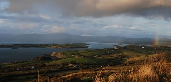
The main Sheep’s Head walk is about 93km long. It begins in the historic West Cork market town of Bantry. From there you hike right to the end of the Sheep’s Head peninsula where you’ll find the Sheep’s Head lighthouse and stunning views across West Cork’s bays and the Mizen and Beara peninsulas.

You might even be lucky enough to see dolphins and whales from the westernmost tip of the headland.

Varied Terrain

Sheep's Head Way Walking Route

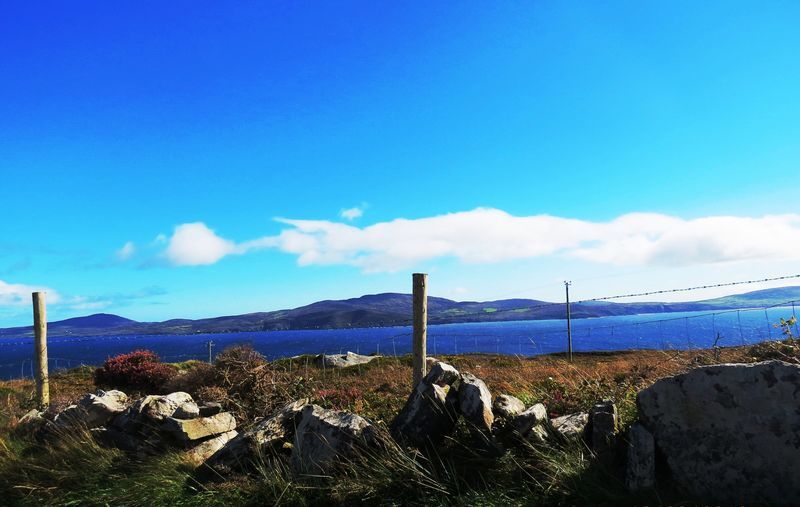
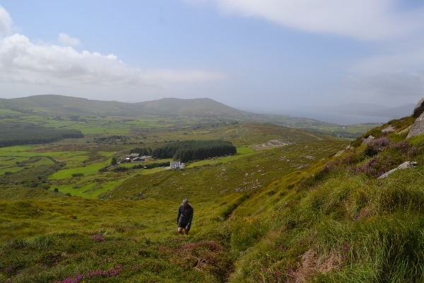
The terrain of the Sheep’s Head Way includes old boreens, open grassy paths, heathery hills, quiet roads, and some short stretches of woodland path. The peninsula has an interesting past: you’ll encounter remains of an old copper mine, a blow hole, stone circles, standing stones, high cliffs, a Napoleonic signal tower and old churches along the way.

When you return to Bantry, the Sheep’s Head Way walking route extends eastwards to Drimoleague and Gougane Barra. This route includes St. Finbarr’s Way, a magnificent pilgrim trail.

Whether you opt to hike the whole Sheep’s Head Way walking route or choose a shorter route that suits you, you’ll enjoy the peace and tranquility on offer in this stunning landscape.

The Sheep’s Head Way is divided into sections, and includes walks of varying lengths and levels of difficulty. You can pick Sheep’s Head Way loop walks, coastal trails, or a walk along the peninsula’s peaks to suit your mood and the time you have available.

The Drimoleague Heritage Walkways and the Carriganass Walks, linked to the Sheep’s Head Way, give you the opportunity to head inland to the West Cork hills.

Our experienced walking guides are available to lead groups: contact them to plan your trip. Details of scheduled tours are available on our events calendar for details of scheduled walks.

Sheep’s Head Way Maps & GPS Files

You’ll find files for your GPS devices and Google Earth below. GPS files for individual loop walks are included on their information pages.

Do get in touch if we can help you with any other aspect of planning your trip. We’ll be delighted to help.


Download GPX Files for GPS Devices:Download Sheep's Head Way GPX file
Download File for 3D View in Google Earth:Download Sheep's Head Way KMZ file
Start/Finish:Bantry West Trailhead
Grade:Varies - parts easy, moderate, and difficult.
Distance:93 km
Estimated Time:5-6 days (based on average walking speed of 3km per hour)
MarkersFollow the Sheep's Head Way 'yellow walking man' markers
Metres Climbed/ Ascent:1626 metres
Maximum Height:236 metres
Dogs Allowed?No
Minimum Gear:Walking boots, rain gear, fluid, and a mobile phone.

Sheep’s Head Way Main Route: Sections

Route Sections
Section 1Bantry To Boolteenagh
Section 2Boolteenagh to Glanlough
Section 3Glanlough to Seefin
Section 4Seefin to Cahergal
Section 5Cahergal to the Lighthouse
Section 6Lighthouse to Letter West
Section 7 Letter West to Kilcrohane
Section 8Kilcrohane to Ahakista
Section 9Ahakista to Durrus
Section 10Durrus to Barnageehy
Section 11Barnageehy to Bantry

Filed Under: Sheep's Head Way

Sheep’s Head Way Section 1: Bantry To Boolteenagh

January 18, 2015 by Dunmanus

Boolteenagh Sheep's Head Walk

The first section of the Sheep’s Head Way walking route leads you out onto the ridge of the Sheep’s Head peninsula

Set out from Bantry town along small lanes and fields to the first ridge section on the Sheep’s Head peninsula, a European destination of excellence.

Distance: 7.3km

IV 99318 48463
The Sheep’s Head Way starts in Wolfe Tone Square, Bantry. With the square and the statue of St.Brendan the Navigator (Naomh Bréanainn) behind you, looking towards Bantry Bay, take the N71 road that runs along the south (left) side of the bay. On the right, at the start of the quay is the Sheep’s Head Way information board and map. Post 001 is attached to a telegraph pole. Opposite, next to the road by the Cinemax cinema is the gatehouse to Bantry House. Go through the gate and follow the drive up to the house.

IV 98756 48181
Pass the house on either side. Just after the house turn to the right, down through the car park and leave through the main gates. The route from the west ends here – be sure to leave through the main entrance, and not through the gardens, or you will be heading off in the wrong direction! If Bantry House is closed, just stay on the main road to 006.

IV 98387 48153
Between a boatyard and a previous gatehouse for Bantry House, turn left into the grounds of the West Lodge Hotel. Follow the path past the ponds and up through the grounds and exit by the main entrance in front of the hotel car park. Cross the busy main road, turn to the left and at marker 5 take the first turn on the right signed ‘Dromclogh’. Follow this small road and you will soon be away from the hustle and bustle of the town.

IV 97650 47712
Turn left onto a smaller road which soon turns into a track and at 8 goes over a stile and along the edge of a field.

IV 96980 47366
Lady’s Well is still a place of local pilgrimage. From here follow the posts across the corner of a field and over a ladder stile onto a road. Follow this road to the T junction at 22 and turn left.

IV 95607 46494
Turn left onto the larger road and go carefully around the bend (I suggest you keep on the left to be seen).

Turn up the small road which will take you steeply up round many sharp bends to the ridge. On the way take a look back as there are several ring forts to be seen and there are good views over Whiddy Island and Bantry Bay.

V 95053 45240
The next section of the Sheep’s Head Way leads along the ridge to Glanlough.

Filed Under: Sheep's Head Way, Walking

Sheep’s Head Way Section 2: Boolteenagh to Glanlough

January 18, 2014 by Dunmanus

Sheep’s Head Way section 2 offers you a beautiful ridge walk with views to both sides over Bantry Bay and the lush valley of Coomkeen.

IV 95052 45241
At the top of the ridge, a track turns off from the road. Along this section are several cairns constructed when the first Ordnance Survey maps were being drawn in the early nineteenth century.

IV 94041 45076
If you want to visit the prehistoric hut site, follow the fence to the right before crossing the stile. The site can also be seen below markers 40-41 as you walk.

IV 93219 44664
At marker 48, the path crosses a track that connects Clashadoo and Rooska. It then skirts around a sea of rushes before climbing again.

Between markers 60 and 61, you’ll pass an Ordnance Survey ‘trig point’ or ‘triangulation point’. This concrete pillar marks the hill’s high point at 224 metres.

IV 91552 43976
The path crosses road at marker 66.

IV 89148 43042
Sheep’s Head Way section 2 of the walk ends at the parking area in Glanlough. To start the next section, turn right, down the road, and take the next left.

Filed Under: Activities, Sheep's Head Way, Walking

Sheep’s Head Way Section 3: Glanlough to Seefin

January 18, 2014 by Dunmanus

The third stretch of the Sheep’s Head Way walk on the spectacular Sheep’s Head peninsula leads you from Glanlough to Seefin via Gortnakilly, or by the Seefin ridge route

Distance: 11km / 4hrs

Sheep’s Head Way section 3 is also part of the Glanlough Loop. It climbs slowly up to the ridge that runs down the length of the Sheep’s Head peninsula. It follows that ridge, with fine views over Dunmanus and Bantry bays, before descending to the low saddle where it crosses the Mass Path at Maulnaskehy.

Section 3 then climbs again, going slightly to the north to the aptly named ‘Windy Gap’. The ‘official’ Sheep’s Head Way main route descends by a track, extended and improved in 2011, to Gortnakilly. A road section leads west from there via the ‘Goat’s Path’ to the ridge below Seefin and Finn McCool’s Seat.

An alternative route is signposted at Windy Gap, following the main ridge to the summit of Seefin.

Windy Gap is a crossroads on the Sheep’s Head Way with several of the loop routes crossing near here.

The Sheep’s Head Way section 3 route is characterised by several ‘kinks’ where geological faults have shifted the peninsula south. At these points, it is important to follow the posts to avoid small cliffs.

IV 89148 43042
From the parking area turn right, downhill and then left at the first junction. Follow the road, taking the right fork.

IV 889 438
The path leaves the road up a track which soon becomes less distinct. At some places, the next post is difficult to spot so keep an eye on the path. After a short climb, look back to see Glanlough.

IV 876 425
Here, Dunmanus Bay comes into view, and you are on top of the world!
In clear weather, the Fastnet rock can be seen across the Mizen. Keep to the path and stay on rocky ground, as there are bog holes between posts 111 and 112.

IV 871 422
At marker 117, the path kinks to the left to avoid a cliff. There are several similar places on this route. Don’t be tempted to head straight for the post across the valley, unless you have wings!

IV 850 417
The Mass Path crosses this route at marker 151: it was traditionally used by people on the north side on their way to mass. Down to the left is Ahakista, and to the North Doonour. This path gives access to both sides of the peninsula if you decide to shorten your walk here.

IV 82913 41167
The route joins the ‘Goat’s Path’ road (marker 190). Turn left (west) and follow the road for 2.6km to the top. A detour is possible down to Gortnakilly pier (signposted) which is very beautiful.

IV 812 395
The route leads off down the ‘Horseshoe Road’ at marker 195, but do continue a short distance to the top of the Goat’s Path where there are good views and picnic tables if you need a rest. Kilcrohane is down the road to the south and the Peakeen Ridge walk leads off from behind the Marian statue.

Alternative routes
At 151 this route crosses the Mass Path giving access to both sides of the peninsula.

At 169, there is the option to walk to the end of this section along the ridge via Seefin (arguably the best option). There is a short link taking you to the Seefin Loop and after the summit of Seefin, there is a descent to Finn McCool’s Seat, or down the south side of Seefin, taking you to the Sheep’s HEad Way South, and a possible long loop back to Glanlough.

Filed Under: Activities, Sheep's Head Way, Walking

Sheep’s Head Way Section 4: Seefin to Cahergal

January 18, 2014 by Dunmanus

Sheep’s Head Way section 4 is a short walking route which brings you down ‘The Horseshoe Road’ from Seefin to the start of the lighthouse walk near the end of the Sheep’s Head peninsula

The Horseshoe Road leads you along a green track and a small road to the parking area at Cahergal. An alternative route, staying on the ridge, is also available.

Distance: 4.8km

IV 81568 39535
The track that forms Sheep’s Head Way section 4 leads off from the ‘Goat’s Path’ road on the peninsula’s northern flank. It’s easy to follow as it winds its way below the ridge, finally descending to the public road.

At marker 200 (IV 78928 38693), turn left onto the road and continue to the parking area at Cahergal.

The Cahergal Loop joins the route here.

To stay on the ridge from Seefin, (longer – but well worth it!), take the Peakeen Ridge route and then turn onto the Cahergal route to reach the parking area by another path.

Filed Under: Activities, Sheep's Head Way, Walking

Sheep’s Head Way Section 5: Cahergal to the Lighthouse

January 18, 2014 by Dunmanus

The stunning walk that forms Sheep’s Head Way section 5 leads from Cahergal via The Crimea and Copper Mines to The Cove and then to the Lighthouse at the end of the Sheep’s Head peninsula.

Distance: 8km

The Sheep’s Head Way section 5 route passes through interesting historical areas and beautiful coastal scenery with high cliffs.

IV 76839 37719
The area you pass through is known as ‘The Crimea’ (pronounced ‘cra-may’) for reasons explained here. There are several ruined dwellings and the old field enclosures can be seen below. The path winds around the buildings.

At Post 220 (IV 76405 37420) the path descends towards a pond which was part of the local copper mine workings. There are several open (fenced) shafts here. The path then crosses a narrow rock ledge – it looks worse than it is at first and there is a helpful hand rail – but don’t look down if you suffer from vertigo! Looking back, you can see some of the mine adits in the cliff face.

Just before Post 222 (IV 76207 37298) you’ll find a terrace of cottages that were occupied by the miners. The mine was worked between 1840-90. An image of the mine workings at Gortnavallig can be seen here.

The path climbs to the crest of the low ridge from where you look down to The Cove. The Cove is a small slip surrounded by low rocky cliffs. At the top if the slip is a memorial to the author JG Farrell who tragically drowned here in 1979.

From here, follow the track uphill.

At marker 235 (IV 76372 36557), turn right off the road. The path goes up between two field walls.

Turn right to follow the road at 238, and then fork right onto a farm track below the house.

IV 74315 35395
A beautiful cove with a waterfall can be seen at marker 258.

At 278m, ‘Daingean’, the Lighthouse loop joins from the south. Continue straight ahead.

The route heads uphill. To go to the lighthouse, continue to the right, past the storage container and go down the steps.

IV 71814 33819
The small lighthouse at the end of the peninsula was built in 1968 to help guide in the oil tankers that were to use the new oil terminal on Whiddy Island. It marks the southern tip of Bantry Bay.

Because of the remoteness of the peninsula, and the lack of a road to its tip, the building materials and equipment for the lighthouse were lifted from Kilcrohane, 9km away, by helicopter and about 250 lifts were needed.

When the construction of the lighthouse and the long flight of steps leading up to it was completed, the helicopter was again used to lift the lantern, optic, standby engine and control gear to the lighthouse which was put into operation for the first time on 14th October 1968.

From the end of the peninsula, you are afforded spectacular views across the Bay and the two neighbouring peninsulas: the Mizen and the Beara.

Filed Under: Sheep's Head Way, Walking

  • 1
  • 2
  • 3
  • Next Page »
Wild Atlantic Way

What’s On

No event found!

Visit Historic Places

Bantry House B&B

The Sheep’s Head is a peninsula rich in history and you’ll find traces of its past all along the Sheep’s Head Way walking route.

Find out more

Pure cork

Featured Activity

Carbery Sailing

Carbery Sailing

At Carbery Sailing on the Sheep’s Head peninsula, we offer RYA-approved sailing courses and chartered sailing trips along Ireland’s beautiful Atlantic coastline Our sailing school is based in Ahakista on West Cork’s Sheep’s Head peninsula – a European Destination of Excellence. All of our sailing courses take place on our Hallberg Rassy 46 yacht ‘Merlin’. […]

More Activities

Featured Accommodation

Sheep's Head Holiday Homes

Sheep’s Head Holiday Homes

The Sheep’s Head Holiday Homes are set in Durrus, at the junction of the Sheep’s Head peninsula and the Mizen peninsula: ideally situated for a family holiday in West Cork The charming development has a pleasant little stream running at its edge and is less than 100m from the village’s shops, pubs and cafés. You’re […]

More Accommodation

This project has been supported by Cork County Council & the LEADER programme under the Rural Development Programmes 2007-13 and 2017-2021.
  • The Sheep’s Head Way
  • Loop Walks
  • Accommodation
Sheep's Head & Bantry Tourism Cooperative, copyright 2018 | Website by Wordhoard Communications